
View from atop Mt. Sneffels, 14,150'
I recently returned from another trip in Colorado, where I spent about two months working on ice cores at the National Ice Core Laboratory. If you're interested in some of the specifics of just what I did in the lab, here's a great write-up on it: Ice Cores! Generally, while I'm out there, and in between my time in the lab, I usually find myself participating in what I like to call, "extracurricular" activities. My first year after my lab work, I actually spent 20 days thru-hiking the Colorado Trail...and this year was really no different. I occupied my time mostly with fourteener ascents, but also made time for an official marathon (Revel Rockies) and half-marathon (Slacker Half), and to help out at an aid station at the Hard Rock 100 Endurance Run.
Colorado 14ers
Before this trip, my fourteener count was hovering at 19. There are a lot of varying opinions on just how many exact 14ers there, but for me, I have identified 60 that I will strive to complete officially. According the the published "rules" of what defines a unique 14er, there are only 53...but I include 5 additional peaks that simply lack the 300' of prominence to be considered official, and then 2 more additional peaks that are unnamed (but also lack the prominence). These "supplementary" peaks are: Mt. Cameron, El Diente Peak, Conundrum Peak, North Eolus, North Maroon Peak, "North Mt. Massive", and "West Mt. Evans". There are actually 14 additional unnamed points over 14,000 that could be included (bringing the absolute total to 74), but for me, my personal goal is the 60.
On this trip I managed to summit thirteen separate 14,000+ foot peaks, ten of which were new (and three repeats). Additionally, I made it about half-way up Challenger Point/Kit Carson, but had to turn around before the summit. I'll try to walk through them as I did them....
Challenger:
Challenger Point was actually the first 14er I attempted, unfortunately, it was way too early in the season, and the snow was just too much for me and my under-trained body. I was down in Crestone for a visit before my lab work, and thought I'd at least give it a try. I have not done any of the 14ers in the Sangre de Christos (Crestone and Blanca groups), so at least wanted to get a lay of the land. Unfortunately though, it was still late May, and the El Nino year made it just too snowy for me. With the right gear, it would have probably been doable, but I opted to cut it short. I made it to just shy of Willow Lake and pulled the plug after over an hour of postholing. It turned out to be the right call as some unexpected thunderstorms rolled in not long after. I didn't take any photos.

Here's the track from it: https://www.strava.com/activities/598755108
Mt. Evans:
Obviously, Mt. Evans is not a new 14er to me. In fact, it was actually the first I ever summited in 2008 due to the easy road access. This time up though, I spent an entire day running up and down it via the toll-road with a local running friend of mine. She was training for Badwater and was trying to get in some long miles, I just wanted to get out on some mountains. I needed a good long acclimatization run at altitude, so what better way than to run the 20+ miles up and down Evans? It was a good day, but the altitude definitely kicked my butt. We took our time and finished many long hours after we started...and managed to enjoy a nice snack and drink at the store once done. It was a nice way to start my 14er season out in Colorado. At the end of the road near the summit, we did have to posthole up through a few hundred feet of snow to the final summit, but it was totally worth it.

Some goats eating the little bits of grass growing out of the road

Near the summit

Climbing the final snow pitch to the top
(can you see us in the snow about half way up???)

Here's the track: https://www.strava.com/activities/600006615
Mt. Princeton and Mt. Yale:
One of the highlights of my time in Colorado, was getting to spend some time with friend and fellow Barker, Jared Campbell. He was making "scouting" runs along the Sawatch range for another possible Nolan's 14 attempt, and asked if I wanted to join him for a hard day up and down Princeton AND Yale. I knew it would absolutely kick my ass trying to keep pace with Jared, but I couldn't pass it up. The Princeton ascent while long, wasn't actually too bad. It took a lot out of me, but I was mostly able to keep up. We summited together and came down the other side in pretty good time. It was over 12 miles total though and left me quite depleted for the next big climb up Yale. Needless to say, I was a mess going up Yale, and felt horrible that Jared had to keep waiting for me to catch my breath. I just wasn't ready to do these 2 beasts in one day. But, he kept patient, and we eventually did summit. The way down was much more pleasant and we managed to get back to some margaritas and good Mexican food in Buena Vista before dark. Our approaches up both peaks were non-standard, meant to minimize time for Jared's possible Nolan's run. We definitely found the most efficient routes and he was thrilled with the the digital tracks we were able to log on GPS.

Here's the Track: Mt. Princeton

Here's the Track: Mt. Yale Track

Chatting with some hikers on our ascent up Princeton

Having some scrambly fun headed over to the summit

A fun little pitch we had to climb on our way up

On the summit with Jared

Later that day, on the summit of Yale...quite exhausted.
Mt. Bierstadt:
The very next day, on incredibly sore legs, C and I decided to do a fun hike up Mt. Bierstadt. I had previously summited Bierstadt in 2011, but it was a new one for C, so we went for it. If it were any other peak, I probably would not have fared so well...but with the mild approach, relatively short overall distance (6 miles), and minimal 2800' of total gain, I decided it would be worth it. Hiking any mountain with C is always better than alone, so I honestly jumped at the opportunity. She would only be out in Colorado for a few days and I wanted to make the most of it.

View from about half way up

Nearing the summit

Looking over at the Mt. Evans Summit

USGS Benchmark

Looking East from the summit
Missouri Mtn, Mt. Oxford, and Mt. Belford:
After Bierdstadt, all but one of my subsequent 14er trips were done flying solo. My trip with Jared up Princeton and Yale made me realize I could reach the Sawatch range in just over 2 hours from South Lakewood where I was staying, so I made the decision to focus all of my future efforts on knocking out the rest of the Sawatch/Nolans peaks. I had only done 4 of the 14 before this Summer, so I had my work cut out for me. I also wanted to try do do some of the climbs with Nolan's in the back of my mind, in case I ever decided to actually go for the full traverse one day.
My first big effort was a the triple Missouri/Oxford/Belford route. Doing three peaks in one go may sound like a lot, but honestly, this was a fairly straight forward and easy day. I drove to the Missouri Gulch Trailhead at about 5 am, hiked up the valley....climbed Missouri, and then made my way over to Oxford and Belford. Connecting all three meant I had to improvise a little, but thankfully it was along the Nolan's route. I dropped down off of Missouri's South ridge into the valley, and free-hiked my way over to the Elkhead Pass trail. From there, I hiked up to the saddle, and then up towards Belford's peak. I opted to first skirt over to Oxford and tag it, before coming back and finishing out with Belford. From there, I hiked straight back down Missouri Gulch and back to my car. The whole effort (at a moderate pace) took me about 8 hours...and was an absolute blast. I was back at my car by about 2:30 pm.

Here's the track: https://www.strava.com/activities/622126441

About half way up the Missouri Climb, looking back down the gulch

Sun rising along the mountainside

A look up to Belford and the trail I'd later be coming down

Missouri Peak (up-center)

Missouri Peak getting closer...

Approaching Missouri summit

Looking towards Huron

Summit just ahead

USGS Benchmark

Obligatory Benchmark Photo

View down Missouri Gulch from summit

View from near Belford Summit over to Oxford

Mt. Harvard (center left) as seen from hike over to Oxford

USGS Benchmark for Oxford

Obligatory Oxford summit photo

On Oxford's secondary summit looking over to primary summit

Mt. Harvard, Princeton, Yale, Antero, Shavano, Tabeguache (all visible)

Summit Photo on Belford

Ridgeline hike on Belford

View from Belford Summit

View back over to Oxford from Belford Summit

Final Summit pick from Belford before heading back to car
Mt. Elbert:
I wouldn't have necessarily opted to do Mt. Elbert again (I had previously done it twice before), but in this case, C was back in town and she had not done the Colorado High Point. This of course meant another 14er...which was fine by me! Elbert is always a nice hike, but despite the relatively moderate trail-tread and gradient, it is still 12 long miles with over 4300 feet of total gain. It took a lot out of us both, but it was still a good time. This peak is the 2nd highest in all of the lower 48 (and the highest elevation that C had ever been), and we both were certainly feeling it near the top. Here are a few pics from that trip and our track:


Early on below tree line

View from just above tree line (~12000')

View over to Mt Massive

Looking up at the (false) summit of Elbert

Can you find the Pika?

Wildflowers near the summit

At the top, with a little snow still hanging around
There were about 40 people on the summit.
Mt. Harvard and Mt. Columbia:
After our little excursion up Elbert, I took a little Hiatus from 14ers and focused on lab work. I wasn't actually sure whether or not I'd get in any more summits, but one thing kept nagging at me. Ever since looking over from the Belford/Oxford traverse...I couldn't get Harvard out of my mind. It was such a beautiful looking mountain and I definitely wanted to hike it. There was just something about it. Two weeks later, I was heading down to the Hardrock 100 to captain an aid station, and I decided to leave a day early in order to bag Harvard on the way down. After looking up the standard route, I decided to add in the Columbia traverse as well, since it really didn't add much distance, and would allow me to do that section of the Nolan's course. Honestly though, I really only just wanted to see Harvard. It turned out to be a very long hike (7 hours), but it was probably the most amazing of any 14er to date. It was simply spectacular. The traverse over to Columbia from Harvard was a fair bit more difficult than I was expecting and required a significant descent down from the ridgeline. I was quite depleted after Harvard, and really went slow over to Columbia. Still, I made it in one piece, and was able to easily descend back down into the Horn Fork basin and eventually down to North Cottonwood Creek and my car.

Here was my track for the day: https://www.strava.com/activities/640645152

Mt Harvard in distance

Looking back down trail towards Yale in the distance

Bear lake nestled high up in a glacial cirque at 12k

Final pitch up to the Harvard Summit

Looking over towards Columbia and the traverse connecting it

Mountain goat near the summit

View form the Summit to the Northwest at Belford and Oxford

On the summit
View back down the Horn Fork Valley

Obligatory summit shot (no USGS Benchmark)

Yo...you got some food for me?
Another summit shot

Starting on the Columbia Traverse

About 1/3 of the way over to Columbia

Looking up to the Columbia Summit

Looking back at Harvard and the traverse line

Obligatory Summit photo from Columbia

View from Columbia with Harvard just in sight on the top right

On the descent from Columbia looking back at the summit with Harvard also in view
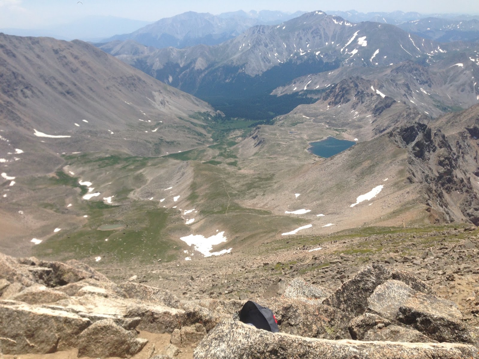
Mt. Sneffels
A few years ago, C and I tried to summit Sneffels while on vacation in Colorado. Due to inclement weather however, we had to turn around before starting the final summit push up the boulder field. Well, this year, I knew I'd be in "the neighborhood" for Hardrock weekend, and I had a Jeep with 4WD. This meant I could drive up to the Upper Trailhead, and limit my hike to about 4 miles round trip. Turns out, I was a little over optimistic about the Jeep and settled for a start at the lower trailhead about 2.8 miles from the summit (meaning a 5.6 mile round trip hike). Still, I was excited for the prospect of a 2800 foot, 5.6 mile, 14er hike.
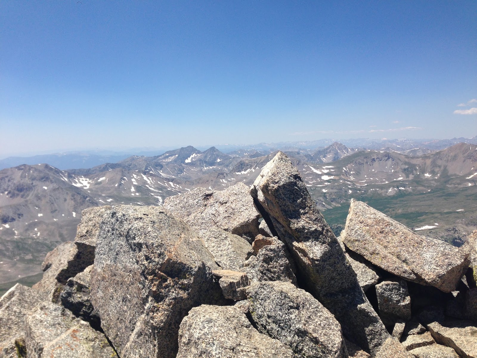
After getting all of my logistics in order for Hardrock, I bolted over to Sneffels and made it to the trailhead just before 5. I was lucky in that it was a late afternoon in July, with no rain or indication of thunderstorms. I made quick work up the trail and was up to the final saddle in about an hour. The last pitch was a little dicey due to recalcitrant snow packs, but I skirted around and post-holed as best I could to finally top out on the summit. I really enjoyed topping out on this peak, as I was the only one up there, and because the actual summit was so diminutive. The summit area itself was roughly a circular patch of ground maybe 10-15 feet in diameter. I descended quickly, finding a better route around the snow, and was back at my car in just over an hour...making my entire hike about 2 and a half hours total. I was back in Silverton relatively early, and ready to watch the Start of the Hardrock the next morning.

Here was my track: https://wwwstrava.com/activities/641352746

Heading up the road to the upper trailhead. Sneffels summit is left-middle

At the upper trailhead looking back down the valley

Beautiful glacial debris flow with a terminal lake

Looking up the big boulder scramble to the summit

View across the valley of the San Juans

Nearing the summit

Boulder fun

Amazing views...

View down to saddle from just below summit

Amazing view from the summit

On the Summit!

Tiny summit area to enjoy

Another view from the summit

Probably the best photo from the entire hike...simply stunning with the sun setting

Obligatory Summit Photo (no USGS Benchmark)

The next day in Silverton, admiring the "Hardrock"

Start of the Hardrock 100!

This plaque...some day, I will get to kiss it.

Killian and Jason finishing together

Captaining an aid station is really fun (and delicious!)

Jeff Browning...coming in 3rd

Blake Wood finishing his 20th! Stuff of legends right here.
Mt. Shavano and Mt. Tabeguache:
Last but most certainly not least, I had the opportunity to make one last trip to the Sawatch before heading back east. This time, to bag what I had hoped would be the last three peaks...Shavano, Tabeguache, and Antero. My plan was to hit Shavano/Tabeguache as early as possible, knock them both out quickly (Tabeguache is only 1 mile away from Shavano with just a few hundred feet of climb/descent), and then drive up to the Antero trailhead and bag it too. This would effectively finish out the entire Sawatch range and Nolan's route. The short story is the Shavano/Tabeguache combo went perfectly, and I was back at my car before lunch. But, by the time I made it over to the Antero trailhead, thunderstorms were brewing. In addition, there were about 50 4-wheeler trailers at the trailhead, meaning the trail would be teaming with vehicles. Antero is the only peak in the range where the standard approach trail is also a 4-wheeler trail. Needless to say, I didn't want to deal with all that chaos, nor the possibility of lightning, so I decided to leave one last peak for my next Colorado adventure. Still, my climb up Shavano and Tabeguache was quite lovely and I was happy to knock out two relatively easy peaks in just a few hours.

Here was my track: https://www.strava.com/activities/649085508

At the trailhead

Turning off of the good ol' Colorado Trail. So many memories of the CT.

Breaking through treeline
View out over the valley

On the final climb to the summit of Shavano

Obligatory Summit photo: Shavano

View over to Tabeguache just a short mile away

Getting a good view over to Antero, which I was hoping to do later

Looking up to the Tabeguache Summit

Looking back over to the Shavano Summit

Antero as seen from the Tabeguache Saddle

On Tabegauche, looking over at Shavano

Obligatory Summit photo

Summit marker?
...And that's where it ends. I had hoped to do Antero, but as I wrote above, it just didn't work out. After this frenzy of 10 new peaks, my 14er count now stands at 29 of the 60 I am aiming to complete some day. So essentially, I'm half-way done! I'm excited to have the Sawatch nearly done so that I can focus on a new group of mountains during my next trip. If I spend any significant time in Colorado next year, I hope to earnestly tackle the Blanca and Crestone Groups (Sangre de Cristos).
For now, I will be content climbing peaks back east and enjoying the fading sunlight of Summers in New England. I'll leave this post with this final picture taken this past weekend on the summit of New York's Mt. Marcy...my 33rd State High Point.


Take care all, and always keep exploring.
-J