
A 10-yr journey coming to an end...
I've spent the past few weeks thinking about just how I wanted to write my "run report" for my Hardrock 100 experience and I never really did decide on just what I wanted to say. One of the things that I did not do during my run was carry either a camera of any kind (nor any sort of music). I wanted to fully immerse myself in the moments as they happened in the mountains, and be unburdened by any need to stop and take photographs. Because of this, nearly all of my memories are with me and me alone...as intended. I am never particularly fond of "brick wall" race reports that are just composed of text, so in this case, I am choosing to use screen grabs from google street-view along the course to better illustrate. Yes...you read that right...you can google street view the entire course. So keep that in mind.....every picture you see of the course itself, was not during my race, but rather from Google view.
I suppose I will do my best to paint the most accurate pictures of my experience, but I can honestly say already that words simply cannot relay just what it was like being out there. The beauty and awe I experienced looping my way around the San Juans is indescribable and only solidifies my opinion that these mountains are among my favorite in the world. Still, I will retell my experience as best I can in hopes that maybe with some imagination, you can perhaps see inside my memories and have a sense of what I experienced.
Many, many people asked me about my "goal" for Hardrock. It's a bit of an easy "cop-out" to take the canned answer of "I just want to finish", but considering my history with even gaining entry into this race, I don't feel like this was a disingenuous answer. I suppose my back-of-the-envelope estimation was about 38 hours, but my real thought on the matter was I just wanted to take in the course for all it was, and eventually make my way around before time ran out. I had a few time goals...like hoping to climb Handies in the dark, making it to Ouray in the daylight, and trying to maybe finish before too late on the second night, but I also knew that A LOT can alter plans at Hardrock. The altitude, weather, and course difficulty can significantly change any prepared runners plans. Knowing this, I went into the run fully aware that whatever "plan" I had, would likely evolve. I packed a few drop bags accordingly, and simply set forth onto the trails with wide eyes, an eager smile, and was ready to absorb whatever magic I could. My one rule was that I would not rush myself. It may well be another 5 years before I get another go at Hardrock (despite my new lottery category), so I wanted to stop at the beautiful vistas, enjoy breaks on the passes, and take my time on technical descents. I did not want to "miss" anything. So, with all this said, I will do my best to recount my memories of the event, but will also try to keep it on the simple side as there are very few pictures.
My experience at Hardrock was definitely in the top 3 of all time race/run experiences I've ever had, and probably #2 when it comes to overall emotional impact. As far as scenery, putting aside my thru-hikes, it was definitely the most spectacular of any event I've done thus far. No comparison.
REPORT:
As I noted in my previous post, I spent the week leading up to the run by spending as much time at altitude as possible, and bagging several 14er mountain peaks. C and I spent 3 days in and around Chicago Basin, and I also speed-hiked several early morning mountains on other days (making sure to be back at the car by 10 am so we still had a full day of adventures to enjoy). I tried to spend as much time over 10,000 feet as possible so that I would at least have some acclimatization before the race. Living where I do in New England, I am rarely over 1200' elevation, so as a "flat lander", I knew I needed that precious time above tree line.
We hiked the 4 miles down from our campsite to the trailhead and waited for hours for the train to come. Eventually, we were greeted by a local resident who happened to be staying in her remote cabin near the trailhead. She informed us that she received a message on her satellite messenger notifying her that the Silverton-Durango train had been shut down due to a massive mudslide onto the track from the heavy rains the night before.
"What are our reasonable options?", I asked her.
She says, "Honestly, you're probably best to just hike it back to Silverton. It's 13 miles along the tracks"
Ugh. The last thing that C and I wanted to do after a big hiking/camping trip in Chicago Basin was to hike 13 long/hot miles along the tracks back to Silverton. But, without knowing anything about how long the train would be delayed, we figured we had no choice. The local was kind enough to fill our water bottles, so we at least had hydration to get us there. We also had one leftover dinner from our camping that we ate to keep us fueled.
The hike ended up being closer to 14 miles, and it really beat us both down. It wouldn't seem like walking on tracks would be hard, but it really is tough on your feet. The exposed sun didn't help. This was not how I wanted to be spending my "taper" day, but there was nothing we could do about it. It took us 5 hours to make the walk, and when we got to Silverton, it was already dinner time. We were both a bit grumpy, but after cleaning up in our van, and getting a real meal, we both felt better. We skipped out of town quickly in our van and camped up near Molas Lake, just to get someplace more remote and prettier (and at higher elevation).
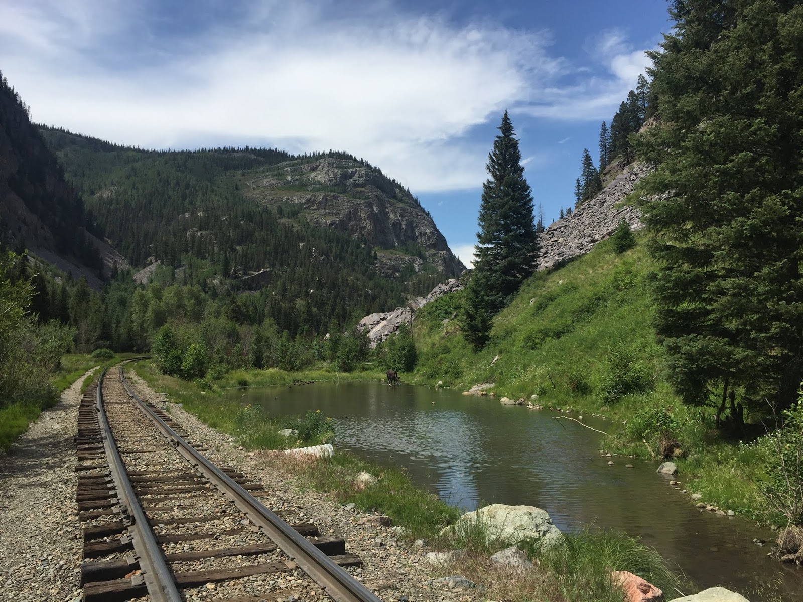
Our view for 14 miles (note the Moose in the pond)
On Thursday morning, we came down into town, and I finally started mentally putting myself into "Hardrock" mode. I took some pictures around town, and made my way to the runner briefing. I officially checked in, received my runner bag and bib, and then took a seat for the briefing. There wasn't a whole lot of useful information relayed at the meeting other than the common sense stuff, but it was still quite surreal to be there. There was a lovely video tribute to Bill Dooper, and a few poignant talks by young scholarship recipients.
When it was over, I raced over to the Grand Imperial hotel in order to sort my drop bags frantically (I had about 30 minutes to get them to the drop off point). With some quick thinking and help from C, I managed to get 5 bags dropped off in time, and then had the rest of the afternoon to essentially rest....something I probably should have been doing more of the previous week. We went to a local coffee house and worked on our laptops for a while (I still have a manuscript in review that needed to be edited). I had booked a nice room for the night at the Grand Imperial, as I wanted to assure I'd get a comfy and good night sleep before the run. I also booked a room for the 2nd night of the race (Saturday), hoping I'd be done in time to use it. I knew at the very least, C could use it. We didn't do much Thursday night, and after a quick bite in town, retired early so that I could get ample sleep.

Finish line chute on Thursday morning

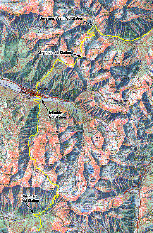
Official Map

Checking in!

Signing the 2018 map!

Getting my official runner photo taken

This year's aid station specials

Awesome Coffee house in town to work
(http://www.sagehencafe.com)

Runner Briefing

Runner Briefing

The Start/Finish line, ~15 hrs pre-race.
I woke up race morning feeling quite calm. I suppose on some level I was really excited, but my overall feeling was more of true contentment. I was eager to see the beauty along the course, but I didn't want anything to feel rushed. I knew in just a few hours I'd be out there experiencing it. I got showered and dressed quickly while C popped down to the cafe to get me a muffin and coffee. I dressed for lots of sunshine and warm weather, but had an emergency layer on hand (as well as afternoon rain gear in my drop bags). I had a very small emergency headlamp as well in case it got dark before arriving in Ouray. The photo below was taken just moments before heading out to the starting area to check in (probably 40 minutes before race start)

Ready to experience the San Juans

Checking in one final time before the race starts

About 2 minutes before race start. I definitely had an eager grin.
I was somewhat surprised at the amount of people all flocking around the start, but considering the field was 140 runners and most had crews of at least 2 or 3, it made sense. There seemed to be a fair number of media folks around too. I just kept looking over at C on the side and smiling. She could tell I was excited. I had spent two summers in Silverton as a Hardrock Aid Station Captain, watching the runners leave town at the start of the Hardrock. I had always wondered what it would feel like to be among them
About 60 seconds later, Dale completed a 10-second countdown, and I began running down 12th street and turning onto Snowden....and knew exactly how it felt. It was bliss. I waved at C one last time as I headed down the road to start my first big 3000 foot climb up to Putnam/Cataract Ridge....and was practically giggling.

Entire Hardrock Profile

Section 1: Start - Chapman Aid Station (~18 Miles)
I ran along the streets of Silverton and up onto the first trail in the first 2 miles before the crossing of Mineral Creek. I ran this bit with Nikki Kimball and we talked about Vermont quite a bit (her home state, and my adopted part-time home state). The field was crowded in this single-track stretch, as expected, and I was simply trying to find a suitable pace. Running with Nikki, I was clearly going too fast.
I crossed the creek and eased up a bit. Somehow I managed to find Blake Wood and we hiked/ran the entire climb up to the pass together. We traded Barkley stories, research stories, grad school stories, and various other fascinating topics. Of all the places to be having a fun conversation with Blake Wood...on the first climb of Hardrock. I'll never forget those first few miles.
We made it above treeline and I was still moving well. I could feel the altitude, but was fine. This first climb had a respectable 3000 feet of gain, was was a good primer for what was to come. As I reached the top of the first pass, I had to stop for a bit to admire the magnificent views. The upper part of this first climb was all "off-trail" so I realized that not many get to see the San Juans from this particular vantage point. I realized at this point, that I would likely be taking a lot of similar type "breaks" along the course. I was perfectly content with this, as my entire goal for my run was not just to finish, but to savor every moment, and take in the incredible views. I ran along Cataract Ridge over to Porcupine Pass with a huge grin on my face...and then began my first descent.
The drop down to the first aid station at KT, was only about 2000 feet of descent, and just over a couple of miles. It went quite quickly and I was rolling into the station in what seemed like minutes. I got my first taste of just how amazing the aid stations were going to be throughout the race when I feasted on super tasty avocado wraps and rice balls. It's important to note that at this point, I was eating well and quite ravenously. I note this because later in the race, I essentially lost my entire ability to eat sufficiently, really costing me both time and energy.

And we're off!
The Start

The Mineral Creek Crossing

Near Cataract Ridge

Porcupine Pass
Section 1: Start - Chapman Aid Station (~18 Miles)
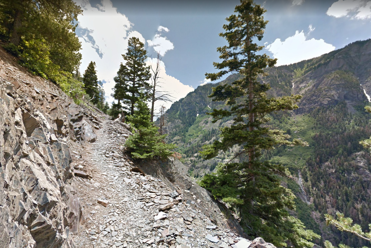
After rounding a sharp turn in the course, we all began the big climb up to Grants Swamp Pass. Despite it's rather unflattering sounding name, this was one of the most spectacular places on the course. On the final section just before the pass, you run by the iconic "Island Lake". I must have stopped a dozen times to look. It's hard to describe in words just how magnificent it all was. The water was unnaturally blue, the sun was out, and the crisp morning breeze was perfect. It was during this point of the race, I was at one of my higher mental points of the entire race. There was some loose scree towards the top of the climb, but once on the ridgeline I was stopped for a long break to eat something and admire the views one last time. I paid my respects to the Joel Zucker memorial that is perched on one of the highest rocks on the ridge, and made my way over to the infamous descent. I knew it was steep, but wasn't quite prepared for it. I looked down at the drop, looked at a volunteer standing at the top and said, "Wait, I go down that!?".
She responded by simply saying, "Welcome to Hardrock. Have fun"
All righty then. And with that, I plummeted down the gnarly scree field, partially by shoe-skiing, and partially by riding on my backside. In those few minutes as I dropped several hundred feet, I thought longingly of the shoe gaiters I opted NOT to wear just before the start of the race. I stopped twice to empty my shoes out at the bottom. Something that hadn't occurred to me, but that I realized later after talking to several Hardrock Veterans, is that this year the course was completely, 100% snow-free. This has never happened before and was due to the incredibly warm summer (with low snow falls), and the one-week later start. What this meant was that on certain parts of the course where it is actually beneficial to have snow for the purpose of glissading down, you had to instead slide down rocky scree. I feel that this very likely made some steep sections more difficult and slow going.
Here's a video I found of the 2016 race leaders careening down the descent:

Photo of Blake Wood at Island Lake (on the ridge)
(Photo from Durango Herald/Blake Wood)
Once the descent leveled out a bit, I tried to get back into a suitable running pace, but found it difficult. I wasn't sure what the deal was, but I wasn't running well. I would try to pick it up for a bit, but found I was completely sapped. I tried eating some of my carried food, but it wasn't doing much. I decided to not let it get me down, and instead just take it easy down to Chapman. I had a drop bag and lots of good food waiting.
Somewhere in this stretch, back below treeline and along a creek, I was running through some thickets of flowering plants. Things were going well, and then I was instantly struck with a searing pain in my left calf. I yelled loudly and the runner behind me immediately asked if I was all right. I was confused as to what had happened. Had I catastrophically pulled a muscle? It didn't feel like that though, It was more localized. It almost felt like a ....
...and then I heard three other runners behind me also scream loudly. Yep, we were all stung by yellow jackets that apparently had been hanging out in a group on some of the flowers. It has been many years since I was stung, but I definitely remembered how unpleasant it was, especially right on my calf. One of the runners behind me got three stings, one his leg, one on his hand, and one on his cheek! Thankfully, I got off easy. As far as I know, no one was allergic, which was my first real panic thought. We were still a good 4-5 miles from Chapman. The sting really lit a fire under me and I managed to pick up the pace over the next few miles. I was surprised at how long the pain of that damn sting would stay with me for the remainder of the day.
When I did finally roll into Chapman, I took my time resting. I thought it would do me good to take a real/honest break as I had only stopped for about 2 minutes at KT. I noticed though that I was already becoming indecisive at the station with what I wanted to eat. It was definitely too early to be getting picky about my food options. I should have been wolfing down everything...and instead I was lightly picking little bits of things here and there. I knew this wasn't good, but just wasn't interested in the food even though I absolutely knew I had to put down calories. This was a cycle that would compound throughout the remainder of the race, making me more and more lethargic. I've noticed with races lately that this is becoming a bigger and bigger problem. I'm not sure if it has to do with my stomach getting weaker, or simply my age...but I just can't wolf down anything like I used to in an Ultra. I'm going to have to think long and hard about my strategy for this going forward as running without adequate fueling is not sustainable. The days of subsisting on just gels, Clif Bars, and water are long gone.

Site of KT Aid Station

Along the trail just up from KT - One of my favorite sections

Island Lake

On Grant's Swamp Pass - Zucker Memorial Plaque in view

Looking down the Grant's Descent
Section 2: Chapman - Telluride Aid (~10 Miles)
Leaving Chapman after a decent break, I felt much better. I would be starting the next climb in the early afternoon, to what would likely be thunderstorms. I was just hoping not to be caught on the next ridge during any lightning. The climb up to Oscar's Pass, would feature about 3000 feet of consistently steep gain, with an exceptionally steep bit at the top. Even the course elevation profile shows this as a near-vertical straight line. This was probably the first really tough climb of the course, but I was ready to tackle it. I put my head down, and decided to keep my pace a bit slower so as to keep moving steadily, and avoid what I call "breathing breaks" (when I stop for 10-20 seconds to rest and catch my breath). For the most part, this strategy worked well. The combination of the food at the station, and a slower/more consistent pace, kept me moving well all the way up above tree line. Once the pass was in sight (at about 12,000 feet), I started slowing again. It didn't help that this was also an incredibly steep part of the climb. I definitely could tell that the time I spent in Colorado before the race had helped me significantly with altitude, but I still had trouble moving quickly once over 12,000 feet. Every climb on the course I noted this. As soon as I'd get above 12k, I started laboring hard. I think the only way to truly avoid this is to simply spend more than 10 days at altitude, or use an altitude tent before the race. I didn't have the time or money to do either of those, so knew it was just going to be a bit difficult during the few points of the race that are over 12k. Thankfully, there are not too many miles over that elevation. I struggled with the final 500 feet of this climb, but once on the top, I knew I'd have a nice, long descent into Telluride...with a very run-able jeep road section for about 3-4 miles. The clouds were thick as I crested the pass, and it did rain a little on me....but the lightning stayed away thankfully. I figured by the time I was above tree line again after Telluride, the afternoon thunderstorm window would be over...so I likely dodged a big bullet.
The descent was quite pleasant. The upper basin was filled with wild flowers and sweeping single-track trail; some of the best I've ever run on. My smile came back quickly and as I dropped in elevation, and my oxygen levels increased, I felt a new sense of excitement. I chatted a bit in this section with another runner about Barkley and we both were pleased to see the sun come back out once we were down to the jeep road. Once on the level road, I decided to shift gears and run the rest of the way into Telluride at a good clip. It felt great to move well, but I was also a little extra motivated to make it to Telluride because I had a sneaking suspicion that C was going to surprise me there.
Our original crewing plan was for C to first meet me in Ouray at mile ~43. It's a really long drive to go all the way around to Telluride from Silverton, so we just planned to skip it. I had a drop bag there so was fine with this plan. But, with that said, I had a hunch that she might have made the drive anyway. I obviously wasn't "expecting" to see her there, but I also had a hunch that she might be. It gave me a little extra zip in my steps wondering if I'd see her in town.
I finally turned off the road and was directed across a large park field over to an enormous aid station extravaganza. There were A LOT of people there...with lots of loud music playing. This was certainly quite different than the remote KT or Chapman stations, but was welcome for sure. With no sign of C, I slowed my pace as I approached the ribboned chute leading up to the station. I called out my number, looked to my left and saw her standing there. I totally called it! I had the goofiest grin on my face and was ecstatic to see her. I had realized that with the pace of Hardrock, waiting until mile 43 to see your support, could be over 12 hours. I scampered through the checkpoint and sat down with C for a long break. She told me I looked great (although not necessarily feeling it)....and then proceeded to feed me fresh baked goods from the Sage Hen Cafe in Silverton as well as a plethora of other amazing food that I didn't even know I was craving. Yay for cold/creamy coffee drinks, mango slices, chocolate, and ginger ale! Om nom nom! I did not want to leave.I told her stories about the run so far, tried to express in words just how lovely it was, and of course news of the bee stings to a slew of runners (including myself). It was good to sit with her and talk.

All parts of the course over 12,000 feet
Reluctantly, I eventually got up and started to make my way out of the aid station. I knew that I had a very long 4000 foot climb ahead, that would not be easy. But...it was also that climb that would culminate with a visit to Kroger's Canteen at the very top of Virginius Pass. I was pretty excited to experience the "Canteen", as it is touted as being one of the most unique aid stations in any race. A small station, perched atop a 13,000 foot pass, nestled into a rock wall with ropes and carabiners, and staffed by a complete all-star cast of volunteers (past HR winners and legends). To put into perspective how special Kroger's Canteen is, there is a wait list just to volunteer at it.
As difficult as the 4000 foot climb would be up to Virginius Pass, I also knew that once on the back side descent, I would have an incredibly long road section that would offer me some very easy, run-able miles. Almost immediately after descending you hit Governor Basin and Yankee Boy Basin Roads...both very run-able. But then, Yankee Boy Basin Road becomes Camp Bird Road for about 7 continuous miles of moderately-graded down hill. I was excited for this run into Ouray. My only goal was to try to make to town, the aid station, and C, before dark.

Near the summit of Oscar's Pass

Over Oscar's and starting the descent down to Telluride

Run-able road into Telluride

Section 3: Telluride Aid to Ouray Aid (~15 Miles)
The climb up from Telluride was definitely long. I could tell I had over 30 miles on my legs at this point. I tried to focus on my goal...getting to Virginius Pass and Kroger's. I made the mistake of watching my Garmin too closely and becoming obsessed with my elevation gain. It's like watching water boil...it only makes the climb go slower. Climbing up from Telluride marked my first real low point in the race, and it didn't help that it was also the hottest part of the day. After what seemed like hours, I finally popped out above tree line and could see the pass. It felt good to almost be there and I picked up my pace a bit. As I approached the pass though, I noticed that it didn't look like there was an aid station up there. I figured the people must just be around the back side out of view. But, when I actually crested the pass and noticed also that my altimeter was still short, that I wasn't actually on Virginius. I turned at the top and noticed the long trail contouring around the mountainside up to the next pass about a mile away. It was incredibly deflating, but also my own fault for not knowing the course better. That next mile was really tough, and I was in a grumpy mood the entire time. I tried to fight it off, and remind myself of where I was, but I couldn't shake it. When I finally did make the pass, and saw all of the volunteers cheering from their tiny perch, my spirits lifted. Blake Wood caught back up to me and we hung out together at the aid station. I thanked Rock Horton and told him that I waited 9 years to shake his hand at Kroger's. We both laughed about it and he suggested I not wait another 9 to see him again.
On the steep descent from the pass, the volunteers had strung up a climbing rope to help. This section was incredibly steep (steeper than at Grant's Swamp Pass), and was one of the places that was made even more difficult by the lack of snow. Blake had noted that normally, you can just glissade down the snow with minimal effort. Instead, we had to slowly descend while holding the rope. Once at the bottom though, and on to Governor Basin road, I was eager to start moving again. I knew I had a long 10 miles of road into Ouray...all entirely run-able. I did a water/food check and figured I had enough to make it the 10 miles just fine. What I had forgot was there was actually another aid station at the START of Camp Bird Rd (at the end of Governor Basin Rd)! I made quick work of the high road, and just as I was getting into a groove, I saw a sign that read, "We have awesome food...just ahead!"
Wha?!
Sure enough, I forgot about Governor's Aid Station and was pleasantly surprised by another round of food and fluids! Woo hoo. Nothing quite like a surprise aid station. I didn't spend much time at Governors, but was able to sufficiently rest and fuel up for the 7 mile road run. As soon as I left, I picked up my pace and began casually jogging down Camp Bird Road for Ouray. At my pace, I calculated that I'd make it to town well before dark as I'd hoped. The miles went by fairly quickly, and I enjoyed the nice change of pace from the steep ups and downs I had been dealing with all day. I also knew that leaving Ouray, I'd be facing the biggest climb of the entire course...a 5000' ascent up to Engineer Pass.
At several points along the descent, cars coming from the Mt. Sneffels trailhead would roll by me kicking up dust. At about 4 miles into the descent, a random deer got spooked out of the woods and began running down the road. As it came up on me, it wasn't able to jump back into the woods because the section of road was right over a cliff. So for about a half mile, me and the deer ran together down the road, side by side. It was a bit surreal.
After about 5 miles, I finally passed a recognizable camping spot that C and I had stayed at a few days prior and knew it was only about 2 miles to go into town. The final few miles were relaxing and reflective. I was happy I had made it around the "Western Half" of the course. In my mind, Ouray marked a mental half-way point (even though it was only 44 miles into the race). Being geographically North of Silverton, it just felt like I was finishing half of the circle in a sense. As I approached town, the course takes you along the Oural perimeter trail that follows along a cliffside, and through a low-ceiling rock tunnel. It was a fun little section to experience just before hitting the aid station. I finally dumped down on to the road and could hear the cheering at the station, after having run solidly for almost 7 full miles. It was still well before dark, and I was excited to take a well-earned break and chat with C. Leaving Ouray would be the biggest climbing test of the entire endeavor: 5000 foot climb up to Engineer Pass along the Bear Creek Trail, immediately followed by a climb up to the highest point on the course, Handies Peak (14,000+ ft). The good news is that once over Engineer Pass, and to the very next aid station at Grouse Gulch, I'd be picking up my good friend and fellow Barker, Travis Wildeboer to help pace me over Handies. I was looking forward to some good company through the night. I ate heartily at Ouray...the first time I had done so in quite some time. C brought me some more local baked goods and creamy coffee drinks. I probably put down 1000 calories while sitting there. It was fantastic.

Nearing the pass I THOUGHT was Virginius

Looking ahead to the ACTUAL Virginius

On Virginius at the site of Krogers Canteen

Looking down the descent from Krogers
(Mt. Sneffels is left of Center in background)

Run-able Camp Bird Road

Passing the site C and I camped a few miles up from Ouray

The On-Course Tunnel near Ouray

Section 3: Ouray Aid to Grouse Gulch (~15 Miles)
There's no doubt about it...the climb out of Ouray was an absolute beast. When I left the station, C walked with me through the town streets until I hopped back onto some single track trail. It was nice walking with her. When I finally headed out on my own near the same spot I had come off of Camp Bird Rd just a short time prior, I managed to find Jamil Coury who was out pacing for his runner. We hung together for a few miles as we rolled along the trail parallel to the highway. This section was particularly frustrating as there were quite a few ups and downs that just seemed unnecessary. Eventually, we did finally climb up to the highway and then over it starting the Bear Creak Trail. It was right as I began the switchbacks up the heavily washed-out trail that I finally put my head lamp on. I knew the Bear Creek trail would have some tricky spots, but hadn't realized just how badly the recent rains had washed out some of the gullies and drainages. I felt really good in the cool evening air and pushed the pace quite a bit. In some ways I was disappointed that it was getting dark, as I was hoping to see the cliff-side portion of the Bear Creek Trail in daylight. I could tell, even in the dark, that there were portions where there were shear drops just off to my right. The trail was one of those that was very obviously built right into the side of a vertical rock wall. It was intense, and got the heart pumping a bit quick. But...with it being dark, it was easy to forget.
After an hour or so of climbing, the trail finally left the cliff edge, and began weaving up a higher basin towards tree line. Despite the 5000 feet of total gain, this climb seemed to go fast. Maybe it was spending time with C at Ouray, or maybe it was that both Travis and C would be waiting for me at Grouse...but I was definitely feeling eager to move. Treeline came quicker than I expected and the stars were most definitely out in full force. I've spoken of this before in other race reports, but I simply love the night hours during a long ultra. I was in my happy place for sure.
The Engineer aid station is actually located about 1000 feet below the pass itself, so it gave me a nice break in the climb. I don't remember exactly how long I stayed at the station, but it seemed like I was in and out relatively quick. I remember I didn't eat much though, which did come back to haunt me. I suppose I figured since I had eaten so much at Ouray, I didn't need much. This was definitely not the case. I had easily burned those 1000 calories already. What this all resulted in was a very slow final 1000 ft climb up to Engineer Pass...and then a slow descent down to Grouse on what should have been incredibly runable road. Quite simply, I bonked pretty hard going over the pass and it wasn't until I made it to Grouse that I finally was able to recover.
I made it up and over the pass without any major issues other then just being lethargic...and began the long jog down the jeep road towards Grouse Gulch. This stretch of road is actually on the Alpine Jeep Road, so I recognized it from my 2015 Jeep adventure with C. Several miles down the descent...and only about a half mile up the road from Grouse, I looked up and saw a headlamp coming up towards me. I thought to myself, "I wonder if this is Travis coming up to meet me.."
"Travis....is that you?"
"Who else would it be!"
"Sweet! It's so good to see you. I'm definitely bonking a bit, but Handies is going to awesome!"
We rolled into the Grouse Gulch station and he ran ahead to my camper van to wake C up. I felt so bad that we woke her from a nap, but was excited to see her and get some more delicious food. She heated up some veggie chili for me and it was exactly what I needed. I chugged more drinks, ate some mac and cheese, and destroyed the chili.

Starting the Bear Creek Trail and going over the highway
Early switchbacks on the Bear Creek Trail

Some Cliffside Bear Creek Trail

Nearing Engineer Pass in the Upper Basin

On Engineer Pass about to start the road descent

1/2 Mile up from Grouse on the road where I met Travis

Section 4: Grouse Gulch to Sherman Aid (~14 Miles)
We left that aid station about 20 minutes later ready to hammer Handies. I warned Travis, who lives at almost 10,000 feet, that I'd be slow once over 12,000 feet. I hate slowing pacers down, but he didn't care. He said he was just thrilled to be out on the trails climbing a sweet mountain through the night with me. I don't remember exactly what time we started the climb, but some quick math estimates put us reaching the actual summit of Handies right before sunrise. I had never been on a 14er at sunrise, so was definitely looking forward to seeing a beautiful pink mountain sunrise sky from 14,000 feet.
I've spoken on this site many times about my quest to summit all 58 of Colorado's 14ers. Before the start of Hardrock I had just 12 summits left (sitting at 46/58). Incidentally, Travis has actually summited them all himself over a decade ago, so it was fun asking him about some of the peaks I still had to do. There were many times that I could have climbed Handies over the years. It's considered one of the easier ones to climb. Despite this though, I never actually did climb it. I had made a promise to myself that the day I climbed Handies Peak, would be the day I climbed it while on the HR100 course. Sure enough, that day....was today.
Travis and I traded a whole slew of great stories. He told me what's been going on with his family and his new house that he's building...and I rehashed updates about my job and various bits of research I've been focussing on. It was so good to have such great company on the climb, and it made the entire section go so much faster. Once over 12,000, I did have to stop a fair amount of times to catch my breath, but actually did much better with Travis there. The course takes you over American Pass first at about 13,000 feet, but then you drop down into American Basin a few hundred feet....before finally climbing up over 14,000 feet to Handies actual Summit...and the highest point on the entire course. I had forgotten about this little "down-and-up", so managed to get a little discouraged as we were dropping down into American Basin. I suppose I had convinced myself that the climb up to American Pass was Handies itself. Instead, as we topped the pass, I could see the distant headlamps a few miles across the Basin making a switchbacked line up to the actual summit. It seemed like they were 20 miles away, despite only being maybe 3 miles.
Time continued to tick by as we made our way around the Basin and up towards the final push up Handies. Sure enough, our timing was spot on. We crested the final 100 feet of Handies right as the stars were being washed out by a perfectly pink, pre-dawn sky. On the summit, I sat for a time eating some snacks and just gazing at the indescribable view. It was absolutely stunning. We were the only two on the summit except for a photographer who was also snapping some photos of the sky. I wish I could track him down to get a picture of that morning.
The descent down from Handies was slower than I'd hoped. My running was more of a hobbled power hike. We did not make good time on that descent, but I was content to watch the sun rise through it and continue my conversations with Travis. He was eager to meet back up with his wife and kids at Sherman, and I was just happy that the most difficult (and highest elevation) portions of the of course were behind me (at least I thought). We eventually popped out of the woods right at the trail head for Sunshine and Redcloud peaks, at what is now know as the Burrow's Park aid station. I guess this station is somewhat new from a race perspective, but was honestly one of my favorite. They were all decked out in 80's prom theme attire (think "Sixteen Candles"). Travis and I both ate heartily and then made for the final 4 mile run down the road to the primary Sherman Aid Station. Before leaving, I glanced one last time over at the parking area and smiled, knowing I had just been there a week prior in a camper van to hike up both Sunshine and Redcloud. I laughed thinking about my pre-dawn hike and quick breakfast just a few feet from where I was during the race.
Travis and I ran on and off for the four miles down to Sherman, but it was never really consistent. I was still not eating enough, and just not getting into a good groove. Still....I was continuing to move and moving well for the most part. I wasn't having any major difficulties other than just feeling really sapped.

On American Pass looking over to Handies Peak

On Handies Summit looking back to American Pass

On the peaceful descent from Handies down to Burrow's Park

On the run-able road descent to Sherman

Section 5: Sherman Aid to Maggie Gulch Aid (~14 Miles)
When we rolled into the large Sherman Station, I opted to take a little extra time sorting my drop bag, eating more food, and thanking Travis and his family. From Sherman on, I'd be alone again. In some ways I was sad to be heading out alone, but I was also content with the thought of it just being me and the course again. I knew that the climb up from Sherman eventually crosses the Colorado Trail near Cataract Lake, and then again up on Pole Pass. This was one of the few sections I actually remember from my CT thru-hike 10 years ago, so I was looking forward to seeing it in the day light.
I said my goodbyes to Travis and reluctantly began the next climb up to Cataract Lake. Thankfully this climb would only be about 2500 feet of gain. This seemed like nothing after having climbed up out of Ouray earlier. Despite a full rest and refuel, it didn't take long on the climb though to start feeling sapped again. The sun was out in full, and I realized quickly that I no longer had my full brim sun hat to help keep me shaded. This climb was tough, but thankfully went fairly quick and didn't really feature much in the way of steep sections. I was above tree line fairly quickly and traversing a high meadow over to the high point at Cataract Lake.
Once I crested, I really began to notice the direct sun and heat. At one point I huddled under a copse of shrubs just to get a little shade and cool off...but it didn't really help. I jogged on and off down the fairly easy trail towards the Pole Creek aid station which actually came much quicker than I thought it would. This was probably one of the most impressive of the stations as it was so remote. I didn't see very many other runners along this stretch, and after having just spent hours with Travis, it was hard not to feel a little bit too alone. My spirits lifted though when I did get to Pole Creek, and ate some warm soup. The told me the climb up to Pole Pass was under 1000 feet from there and only a few miles...and then I'd get to drop down to Maggie Gulch for more aid. This seemed like a really do-able small section to check off. Most of the segments at Hardrock seem like such big endeavors (14, 15, 16 miles between), that hearing of a 3-4 mile stretch between aid over a pass, seemed so small and easily parce-able. I left the aid with a new sense of purpose: Power hike up to the pass, avoid the early afternoon storms, and make my way to Maggie Gulch.
The hike up to Pole Pass went really quickly and somehow again, for the 2nd day, I managed to split the thunderstorms in half. Perhaps I'd make it through the entire race without really having any major rain or lightning scares? Once over the pass, I actually ran the short section down to Maggie Gulch feeling relatively good. I could see the runners leaving the station heading up the next climb though and my spirits dampened a bit. Leaving Maggie, it looked like I'd have a beast of a climb.
Just as I pulled into the station, the rains came and I had to put on my shell. It actually was a welcome change though as I was tired of the hot sun. I sat for several minutes eating and talking with the volunteers about the next climb. The good news is that the climb to the top was less than 2000 feet, but the bad news is that it marks the 2nd highest point on the entire course. I knew it would be a struggle, but thankfully it was a shorter climb. As I sat there, It dawned on me that I had only about 15 miles left on the course, and over 15 hours to do it. Pending some major disaster, it was looking likely I'd finish my first Hardrock.

Leaving Sherman aid over foot bridge to start next climb

Nearing Cataract Lake

Just past Cataract Lake on the CT
(These are the bushes I tried to get shade under)

Coming down to Pole Creek Aid Station

Cresting Pole Pass and the CT Again

Descending to Maggie Gulch with next climb up to Buffalo Boy shown

Segment 6: Maggie Gulch Aid to Silverton Finish (~15 Miles)
Leaving Maggie, I thought I was going to "hammer the climb". I had my game face on and began pushing hard. It didn't last long though and after only about 1000 feet of climbing, I was struggling again. The sun was out again, and I was cooking on the mountainside. The climb up to Buffalo Boy Ridge is steep and exposed I was thankful that there were no thunderstorms, but definitely struggling.
I recalled a story Travis had told me about this section. He had said, "when you climb out of Maggie, and get to Stony Pass, make sure to cross the road....and don't turn left or right. It can be tricky there".
In my mind, this meant once I topped out on Buffalo Boy Ridge, to not turn...but instead go straight. So, as I finally topped out on the ridge, I was confused the the road seemed so far away. But.. I made sure to follow the trail straight and proceed. In my mind, I had made it over what Travis referred to as "Stony Pass", and was on my descent down to the final Cunningham Aid Station. This was entirely incorrect and led to what I have considered to be the absolute lowest point of the race for me. You wouldn't necessarily think that the lowest point of a 100-miler would come at mile 88...but for me, this was the point.
As I began the descent off of Buffalo ridge, I thought I was descending to Cunningham. But, as I rounded the side of the mountain, and noticed the dirt road coming up to meet me, I realized I was only NOW getting to "Stony Pass". I looked left and right and immediately realized what Travis was saying about how it could be easy to turn down the road. But then I looked across the road and saw what would absolutely deflate me for over 45 minutes. I looked up and saw that the trail climbed back up several hundred feet over what was obviously another pass, and it absolutely crushed me. Even though the climb would only be a few hundred feet, somehow in my mind it seemed insurmountable. I hadn't realized that I was starting to fall off pretty badly, and this realization put me over the edge. I truly thought I was on the descent town to the last aid station, and C waiting for me, and instead I was presented with another hot climb, and another 2 miles of course.
Climb up to Buffalo Boy Ridge from Maggie Gulch

On Buffalo Boy Ridge looking ahead to Stony Pass

The view of Stony Pass and the subsequent climb to the following pass
When I made it to the road, I mustered up a enough energy to get me started on the climb up to the pass, but about half way up it, I lost it all. I sat down on a rock, stared up at the remaining few hundred feet of climb to the pass and completely gave up. I sat on the rock for over 30 minutes deflated, miserable and unwilling to go on. It was a true pity party and absolutely my lowest point in the race. I don't know why this order of seemingly small events had such an impact on me, but they did. I managed to force down some food, and drink some water, but I still wasn't ready to move. I was surprised that in all that time that I sat there, I never saw another runner go by. It was just me, the sun, and Stony Pass. After what seemed like an eternity, my mind finally began the necessary swing. I thought about where I was...mile 88 in the Hardrock 100. I thought about the good weather and C waiting for me just a few miles ahead. I thought about making it to that finish line after 10 years of wanting it. I thought of a cold milk shake at the finish....mmmm
I looked across the road to the hillside I had come down an hour previously and finally saw another runner just pop over Buffalo Boy ridge and start heading my way. For whatever reason, this made me immediately remember that this is still a race dammit...and I wasn't going wallow on the mountainside. I got up, wiped my brow, and forced myself up and over the pass.

The actual rock pile I stopped at on the final climb up to the pass
Once on the other side, it was all down hill to Cunningham. I had a new sense of urgency and as I dropped down the mountainside (rather steeply I might add), I noticed the clouds were also brewing up nicely. Near the bottom of the descent, I fell hard on my ass and bruised my hip rather nicely...but nothing debilitating. A quick brush off and I was off again towards the now visible station and crew vehicles.

Nearing Cunningham Aid (down on road), with the final climb shown
After what seemed like way more than 2800 feet of descent, I did finally make it to the road and within a few hundred meters of the aid station. I slowed to a walk just as the rain started falling. As I approached the station, I saw C walking towards me. She new I wasn't in a good place immediately.
"What's wrong?" she asked.
"I'm just so tired....."
I shuffled inside the aid tent, and sat down in wonderful chair. C force fed me every good food imaginable and I ate every bite. I drank an entire cold coffee drink, pancakes, mac and cheese, gatorade, chocolate....everything. Slowly I came back to life. Large hail pellets began pelting the canvas roof of the station, and it forced me take a little extra long to rest. The general consensus amongst the volunteers was that this late storm was a bit of an anomaly...but was passing quickly. It was weird to see a thunderstorm so late in the afternoon (It was about 6 pm now). I realized at this point, that pending some massive surge, my hopes for a daylight finish were pretty much squashed. I'd likely be finishing after 9 PM. Still, I'd thankfully get up and over the last climb though before dark, which I was content with.
Eventually the hail subsided and the skies cleared. C offered to pace me the last 9 miles, but I told her I needed to do it alone. I had 2700 feet of total gain left on the entire course...a number that just seemed too good to be true. I said my goodbyes, crossed the creek, put my head down and began the long climb up to the last pass: Little Giant. I watched methodically as my altimeter watched counted down my remaining gain. Soon I was above tree line and had less than 1000 feet to climb. My energy level was depleting exponentially fast, and before even reaching the pass, I was already stopping regularly to catch my breath and re-group. Once I was in the upper basin though, and could see the pass, it was as though 1000 pound weight was lifted from my shoulders. I hammered it out up to the pass, but when I got there, my altimeter was still showing a few hundred feet to go. I had assumed this was another one of those "false summit scenarios" so didn't get too excited just yet. On the other side, I started descending...all while thinking "Great....going down, only to go back up again..."
But..after descending about 300 feet and seeing the trail far ahead still descending I started thinking...could this actually be the last descent? There was definitely no down-and-up on the last high point, so perhaps I really did just summit the last pass.
After a few hundred more feet, I truly began celebrating the fact that I was finally heading down into Silverton and I was ecstatic.
...and that's when it all went to shit.
After about a mile of trail descent, the course drops you onto a high jeep road. I had known that you follow a jeep road for a decent amount as other runners had told me that you can actually run a fair amount of the last few miles "down the final road descent". So I began a steady-paced run down the road. Minutes went by as did the miles. I wound through a couple road switch backs and all seemed to be looking good for a fast finish. As I rounded another switchback on the road, it gave me a view back up to the pass and that's when I noticed that somehow in the past 15 minutes as I was running down the road, massive thunderstorm clouds had formed over the mountain. It was after 8 PM at night, so this was a bit bizarre. Usually the quick pop-up storms are a mid-afternoon phenomena. In the time it took me to run that single switchback, rains began falling, and visible lightning began cracking up on the mountain. I felt bad for anyone still cresting the pass itself.
But then I came to an intersection in the road, and realized there was no course marking. I had no idea which way I was supposed to go...and I couldn't remember what the map looked like in this part. It seemed like I should continue down the road to the right, but wasn't 100% sure. So...I figured I would just wait for the couple of guys that I crested the pass with to catch up to me and I'd double check with them. I figured they could only be a few minutes behind me as I wasn't going that fast down from the summit. I looked up the long visible stretch of road I had come down though, and there was no sight of them.
Oh crap. Did I take a wrong turn somewhere? There's no trail markings, and no sign of other runners. Dammit!
I began to panic hard. I immediately began hiking back up the road, convinced I had missed a turn off somewhere (despite being told there was a road run on this stretch). I cursed myself for not studying the course better before the race. How could I have missed a turn!? I was watching carefully. Was I though? I was thinking about the finish and probably missed a flag. I was pissed.
I hiked back up 3 switch backs when I finally saw the yellow shirt of the next running coming down towards me. Thank God I thought. I WAS right. Ok Ok Ok. I only lost about 10 minutes...no biggy. I waited another 5 for the runner to catch up to me with his pacer.
When they got to me I immediately asked them, "Hey guys, we're on course right? I was pretty sure we run this road, but then down there is a split in the road and there's no marking".
These two guys, both from Japan and not native English speakers, tell me that they are both Hardrock Virgins too, and that they only went the way they did because they saw me go that way.
Oh Shit. Not only was I off course, but I led other runners off course. DAMMIT.
The pacer pulls out written instructions and hands them to me. I read them carefully and it does seem like we are on course. As I'm standing there trying to decide whether to just keep descending, or to wait for more runners to show up, the lighting starts cracking louder and louder. While I'm definitely a bit on edge from it, these two guys were absolutely terrified. I could tell that there were frightened beyond belief and didn't care where we went, as long as it was away from the lightning.
We ran together back down to the intersection and simply made the command decision to go right and run.
...and we ran. For what seemed like miles. Still no course markings. I was 100% convinced by this point that we were off course. The lightning was getting louder and closer...and the rains were getting so heavy now, that it was actually flooding the road. I was worried there was going to be slides and washouts on the road.
I eventually rounded a corner and found a local camping beside his truck. I stopped and asked him, "Hey...have you seen a bunch of runners going by here over the past few hours?"
"Oh yeah, they go by like every 5-10 minutes. Some Hardrock Race or something"
"So they've actually been running by on this road right here?"
"Yep. A whole mess of runners."
I wanted to believe him, but I was still struggling to. Why were there no trail markers dammit? The two guys I'd been running with, were so terrified by the lightning at this point, that they opted to hunker down at the local's campsite and hide under his truck. I rounded a turn in the road and finally saw it. A lone trail marker precariously perched at the edge of the road. All at once a wave of stress left my body and I was finally able to relax. I was annoyed that I let myself get so wrapped up in the belief that I was off course. I was annoyed that I didn't know the course better. I was annoyed that I didn't just follow the road to begin with. I was annoyed that this whole experience meant that I lost over 45 minutes, and was now getting drenched in rain, and dodging lightning bolts. The road just wasn't dropping me down fast enough. I was relieved that I was on course, but pissed that I could have probably avoided the rain had I just ran the road to begin with
The lightning was so close now that I was seeing it, and hearing it at the same time, and I was still over 11,000 feet elevation. It was blinding and deafening. I truly felt in danger and was running scared. The few miles along this road, were very likely my fastest miles during the entire race. But..I kept thinking that I was going to get struck by lightning at mile 96 after having gone two days, and two afternoons without having any bad rain or thunderstorms.
I was on my own now, and also now using my headlamp...which was essentially useless as the rain was so heavy, all the lamp was doing was lighting up rain drops in front of my face. I felt like I was in a ship going through hyperspace.
I continued to drop, and would occasionally see another trail marker. Eventually I made it to a trail turn off and began a stretch of single track....and only then finally felt safe from the lightning. It was now completely dark, so I had no sense of where I really was. I felt like I was no where near Silverton, but assumed I had to be right as I was still getting a random trail marker from time to time. I was also now finally out of the main rain cloud, so at least wouldn't have a wet finish.
This stretch, while only about 2 miles long, seemed to go on for an eternity, without any sign I was nearing town. I watched as the minutes ticked away, and my hopes of a sub-40hr finish fizzled out. I had completely abandoned any hope for that when I eventually came up on a sign that read, "1 mile to go!"
What!? How can it be one mile to go? I don't even see town yet! WTF? Did I take a weird turn somewhere?
I looked down and had about 12 minutes to make it in under 40 hours. Screw it...let's go for it.
I picked up my meager pace to an honest run and was pounding along the trail. Within 2 minutes I was out of the woods and heading down on to a main road. Damn....just like that, and without any indication, I was on the edge of town. I had no idea I was anywhere even near town. I was on 14th st running towards town, and knew I had to turn onto Reese st., and then make the final turn at 12th into the finish line chute.
When I passed the 1/2 mile mark, I still had 6 minutes. Damn...it would be really close.
I pushed a little harder and made it to Reese St. with about 3 minutes to go. I ran the two blocks along Reese and towards the well-lit finish area by the school and was overcome by a sense of complete joy. It brought me back immediately to the feeling I had after my first Leadville finish, and even my AT and PCT finishes. I had made it. I was going to finish the Hardrock.
After all those literal and metaphorical ups and downs over the past 40 hours. All those stunning vistas and mountain passes....all the beautiful mountain lakes and rocky switchbacks. All those unforgettable miles along Handies with Travis and the fun miles with Blake early on. All those moments feeling completely defeated, and those moments feeling unstoppable....
I was now in sight of the rock. That damn rock that I refused so many times to touch...until it was at my own finish. That rock that I thought about for over 10 years. That rock that I witnessed so many others kiss during the two previous Hardrock runnings, while I was inside grilling food at the aid station. That rock that I wanted so badly to rest my head upon.
I turned the final corner, saw C cheering for me, ran up the chute, dropped to my knees and finally rested my head upon that rock.
...and it was just as I imagined it would be. Sublime.
Oh...and my final time....: 39 hours, 59 minutes
The climb up to Little Giant

The upper descent down from Little Giant

Popping out on the upper jeep road

Looking back up at the pass along the road.
It was about here that the rain and lightning started

The point on the road descent that wasn't marked where things fell apart...

More of the road descent.
It was in this stretch that I was getting pelted with rain, and nearly killed by lightning

Final single track stretch on the way into Silverton

Entering the outskirts of town

Turning on Reese St.

Approaching the School and finish line

The final turn into the finish...
Finally kissing the rock

Another finish Photo
This report is scattered, and unedited....and yet there is still so much tossing around in my head that I want to say. I wanted to say everything that I was reflecting on, but in the end, it was just taking too long and so many of my thoughts were difficult to put into tangible words and sentences. As I stated at the very beginning, much of this experience is simply mine, and mine alone to cherish in my memories. For most of the course, I was out there alone, with just my thoughts, and the beauty of the course. I saw stars from mountain tops and glacially-carved valleys on descents from passes. I exchanged polite pleasantries with pikas and watched as a perfect pink sky illuminated the most beautiful mountain valley at sunrise. There is so much I wish I could properly explain in words....but so much of it all is really about emotions, and not physical experiences. I suppose its sufficient to simply say,
This run and overall experience, warmed my soul, and filled my heart.
hike on, and keep exploring everyone,
-j
Thank you to everyone that helped me in my quest to both run and finish the Hardrock 100. Friends that ran random long runs with me back home, Travis for pacing me over Handies, Blake for the great miles early on, the countless other runners and pacers that kept me company along the course, my old man for running along with me in spirit, my family back home for following my spot tracker to "keep an eye on me", and of course C, for crewing me, and being there for me at the finish. I recently wrote an email to a friend of mine that I think is rather apropos here. I said,
"Over the past few years I have learned just what it means…to have such a supportive spouse/partner too. I’ve have come to truly learn that any of my “endeavors” really are a team effort now. I know for me, it is sometimes very easy to forget and/or take for granted what some of the things I want to do mean for my other half. We are all so very fortunate to have such support from our loved ones…support for the often ridiculous things we do for ourselves (and to ourselves).
Five years ago if you would have asked me what my favorite part of the Hardrock course might be, I’d probably say going over Handies. Having now finished, I can say that yes, Handies was great….but honestly, the best part about it was that C was there through it all with me….from the training hikes in Chicago Basin, all the way through the multiple aid stations and the eventual finish. I have a lot of favorite pictures from this year’s event…pictures of mountain passes, pictures with Travis going over Handies, etc….but my favorite is still this one….

Thank you C
4 comments:
Thanks John. Lovely read.
Thanks for sharing a great journey. Congrats on getting to the start line and around the course.
Fantastic man! Great write up and a huge congrats on getting your finish. Truly happy for you!
(Glad I'm not the only one that is opposed to touching the rock until it's truly my turn. Hopefully one day!)
Congratulations! Riveting report from start to finish. It's heartening to know that runners with your amount of experience still have struggles on any given day, on any given mountain.
Post a Comment