Sunrise near Roosevelt Lake
Much like with the ultrarunning or thru-hiking worlds, if you spend any time within the greater domain of motorcycling (particularly adventure motorcycling), you will come to learn of various challenges, traditions, and goofy exploits. One only need spend a few hours peeking in on motorcycle forums, or watching a handful of online videos to quickly observe many of these said challenges and traditions.
It's really not all that surprising as with any hobby, there's always those that perhaps dive in a little too deep (which I of course am also guilty of doing myself). With respect to adventure motorcycling, there are certainly the obvious challenges, like visiting every state, or riding across a specific country (or countries). There's a well-known route in the US know as the Trans-America Trail that features thousands of miles of roads and trails that supposedly make for an incredible adventure. Many of the US states (particularly out west), also have what are known as BDR's or Backcountry Discovery Routes. These routes are much more technical and more appropriate for legitimate dual-sport style bikes. Incidentally, the AZ-BDR goes through Flagstaff just a few miles from my house. I've ridden many miles of the route, and much if it is beyond my skill level.
There are several well know routes that riders will take on as a "Rite of Passage". These include the Tail of the Dragon route through the southern Appalachian Mountains, the Skyline Drive in the Northern Appalachian Mountains, the Natchez Trace Trail in the Deep South, or the Going to the Sun Road up in Glacier National Park. Any place there's a scenic and twisty route, motorcyclists have likely penciled it in at one point on their proverbial To-Do list. Here in Arizona, we have several such twisty roads, with the Coronado Trail being one of the more well-known. It's about 100 miles of winding and curvy paved road that climbs up through the White Mountains, topping out about 9000 feet. It's supposed to offer some of the best views in Arizona.
Beyond the single road stretches, many more advanced motorcyclists will plan for years for what's known as the the pinnacle of Western Hemisphere challenges: the Pan-American Highway. This route begins in Ushuaia, the southernmost accessible point in Argentina (and the Americas), and goes all the way up to Prudhoe Bay Alaska. This ride is essentially one of the ultimate grand-daddy "thru-rides" of the motorcycling world.
Aside from the obvious scenic or adventurous routes, there are also a slew of what I would call, "challenges". Much like with the "Cannonball Run" in the auto world, there are various iterations of Cannonball rides involving two wheels. In essence, this challenge involves getting across the US as fast as possible on two wheels. And yes...there's even a Scooter version of this challenge where all riders are limited to 150cc (or less) scooters.
One well known challenge taken on by many riders is what is affectionately dubbed:
"The Iron Butt Challenge"
There are several variations of this challenge, but the standard version essentially challenges the rider to cover 1000 miles on their bike, in under 24 hours. There is an entire website and association dedicated to keeping the rules up-to-date and published, as well as keeping all records of successful rides. In order to successfully complete the Iron Butt Challenge and be recognized by the Iron Butt Association, you must keep detailed records along your ride. This includes all fuel receipts showing date/time stamps, as well as photographs of your odometer with said receipts at each top. In addition, any sort of GPX track of your ride is certainly recommended. The documentation process is arduous and involves several spreadsheets, and forms that must be sent in and certified. The website detailing this challenge (and the other variations can be found here:
Completing 1000 miles in 24 hours may not sound wildly difficult. It essentially means one must just average only 42 miles per hour. However, every stop eats into that average. So, every fuel up (which are much more frequent on a motorcycle), every stop to eat a snack, every stop to stretch your legs or take a photograph, every single stop.....chews into that average. Effectively, this all means that in order to actually complete an Iron Butt Ride, one must plan on banging out long stretches at high speeds in order to bank some time. Breaks have to be kept to a minimum and kept efficient (much like a race aid station). This challenge also means that you need to actually have a motorcycle that can ride at decent speeds for long periods of time. A small, 185cc dual-sport bike just isn't going to cut it. What's really mind blowing, is that there is actually a version of this challenge which involves 1500 miles in under 24 hours (which means averaging over 62.5 miles per hour!
So what does this have to do with me....
Well a few months back, I came to learn of this challenge, and decided I wanted to try it. My quick disclaimer here is that my motorcycle is not a great highway bike. I own a Royal Enfield Himalayan, which is a single cylinder, 411cc thumper. This bike will go all day at 60-65 mph, but once it gets up to 70 it starts to strain a bit. So for me, if I were going to attempt a true 1000-mile challenge, I wanted it to be about trying to stay on more rural and scenic secondary highways where I wouldn't be contending with traffic going 85+ miles per hour (i.e. the Interstate Highways)
With this said, I decided to commit to attempting this challenge at some point, but I decided to "rebrand" it as a "Grand Ride". This is an obvious and intentional play on words, as I would be aiming to cover 1000 miles, with a focus on the scenery and landscapes (not the speed and time). Now of course, I would still aim to come in under 24 hours to officially complete the challenge, but even if I were to finish in 25 hours, I would still be content.
Thus....the AZ GRAND RIDE was born.
Initially, I had hoped to do this ride a bit earlier in the year, but given the intense winter we had in Arizona, it simply wasn't possible. I began to notice an open Friday emerging on my calendar in mid-April and decided to pencil it in as my tentative attempt date.
So, all that I needed to do now, was plan an appropriate route. As I noted, my goal was to have a route that was not only 1000 miles, but made up of the most scenic sections I could combine, that also featured secondary highways that I could hopefully go 60-65 mph on consistently. I also wanted a route that would have me start and end at home. In other words, I wanted to complete a very large loop route.
After many hours of playing in various mapping programs, I ultimately came up with what I thought would be the ideal route. This route clocked in at 1009 miles (giving me a few miles of buffer), started and ended at the gas station 1 mile from my house, followed along scenic routes, had long stretches of secondary highways, and also featured about 100 miles of twisty mountain roads as a capstone section for the route. This route would also have me traveling through just about every ecosystem of Arizona including the high Colorado Plateau, the Southern Deserts, the White Mountains, Navajo Nation, Monument Valley, and several large Volcanic Fields. On paper, it looked epic. It also had regularly spaced gas stations that would allow me to fuel up enough to not have to carry any spare fuel. The southernmost point would take me down close to Mexico, and the northernmost point would have me just 3 miles from the Utah border. The only downside with this proposed route, was it would require about 100 miles of riding along the I-10 Interstate. I wasn't thrilled by this prospect, but it was really the only way to get me across the southern portion as efficiently as possible.

AZ Grand Ride (~1009 Miles)
About two weeks before the my tentative ride date, I took my Himalayan out of winter storage, did a full inspection on it, and took it out for several test rides. I was very careful to properly winterize it the previous December, so thankfully, it was in great shape. With that said though, I was still a bit nervous about subjecting the bike to 1000 miles of riding in one go. It did have almost 9000 miles on its odometer (which is a fair amount for a bike). I checked every bolt, connection, wire, and potential point of failure. By every measure I could tell, the bike was in excellent shape, and it was either now or never if I was going to attempt such a ride.

De-winterized and ready for a proper challenge
And so...I made the decision to go for the Grand Ride attempt. I carefully planned all of the gear I would carry such that I would have what I would need for every weather situation. I would also carry spare tubes, and all of my tire repair equipment. I would carry my extended tool kit and a few spare parts that I normally would leave at home. Lastly, I decided to pick up a small satellite tracker in case I were to get stranded in a really bad situation. This tracker had built in emergency SOS beacon on it, but also would send 10-minute tracking points to a publicly available website that I could then use as additional documentation for my ride. The device I bought was an InReach Mini 2.
When deciding what time of day to actually start my ride, I vacillated on a good start time. Part of me wanted to wait until after sunrise, but then I would be likely riding for several extended hours at night on the back end. If I started too early though (i.e. midnight), I'd likely be really sleepy and still have over 6 hours of darkness during the coldest part of the night right at the beginning. Even a strong coffee wouldn't help me there. So, I decided to split the difference. I would go to bed somewhat early, and plan to start my ride some time around 2:00 or 3:00 am. This would mean I'd have about 3 hours of cold and dark riding at the start when I would be the most fresh, and then would hopefully only have a few hours of riding in the dark at the very end (when I would also hopefully be fueled by adrenaline).
And so....at exactly 3:11 am, on April 14, 2023, I filled up my gas tank a mile from my house, snapped my official "start photo", and began what would ultimately be a true (and literal) Grand Adventure.

My official "Start Photo"

At the start....Mile 0
The first 75 miles of the ride would be cold and I knew it. I prepared for this by drinking plenty of hot fluids before I left, and by layering up as much as I could. I even put hand warmers in my gloves. I knew if I just made it to Pine, AZ (about 80 miles in), the temperatures would warm significantly as I will have dropped over 2000 feet down in elevation just as the sun would also be rising. I've ridden the 75 miles along Lake Mary Road in the cold before, so I knew what to expect. My biggest fear was actually wildlife as this section of highway is notorious for elk movement. So, I had to be extra vigilant. Thankfully, I was fully caffeinated, and fully alert...and the miles went by fairly quickly. One thing that I had forgotten about my planned route, was that I had to add two small detours in order to properly make sure that it was over 1000 miles. One of these detours wouldn't come until the very last 50 miles when I would need to swing through the Sunset Crater/Wupatki scenic loop. But, the first small detour, was actually around mile 20, and I had completely forgotten about it. This detour was short, and only added about 5 miles to the route, but had me looping off of Lake Mary Rd. around Mormon Lake.
Normally, I would have loved this little detour, but given the cold temps, it came as a bit of a nuisance as I just wanted to get down off the high elevations as soon as possible. In addition, this was the one section of the entire ride, where I actually was presented with a small patch of ice, and it was terrifying. Some snow melt off of the flank of Mormon Mountain had run across the road, and when I came upon it, I was going too fast to stop....and had to just ride across it. I thought for sure I was going to slide out, but thankfully made it through without incident. Needless to say, it certainly woke me up and I went considerably slower through the rest of the detour until I was back on Lake Mary Rd.

A cold morning coming down the Mogollon Rim

Mormon Lake detour
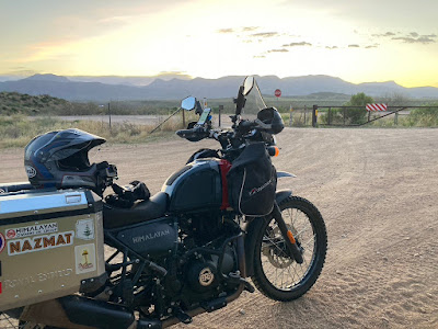
Once I made it down off of the Rim and into Pine, my fingers finally started coming back to life. As I weaved around the town of Payson and down towards Roosevelt Lake, I was starting to get hints of light creeping in over the eastern horizon. I timed the ride somewhat perfectly as the sunrise happened right as I was crossing the Roosevelt bridge and skirting along the shores of the lake. It was quite lovely to see the sunrise, contrasted with the water of the lake, and the saguaro cactus on the hillsides.

The route from Payson down along Roosevelt Lake
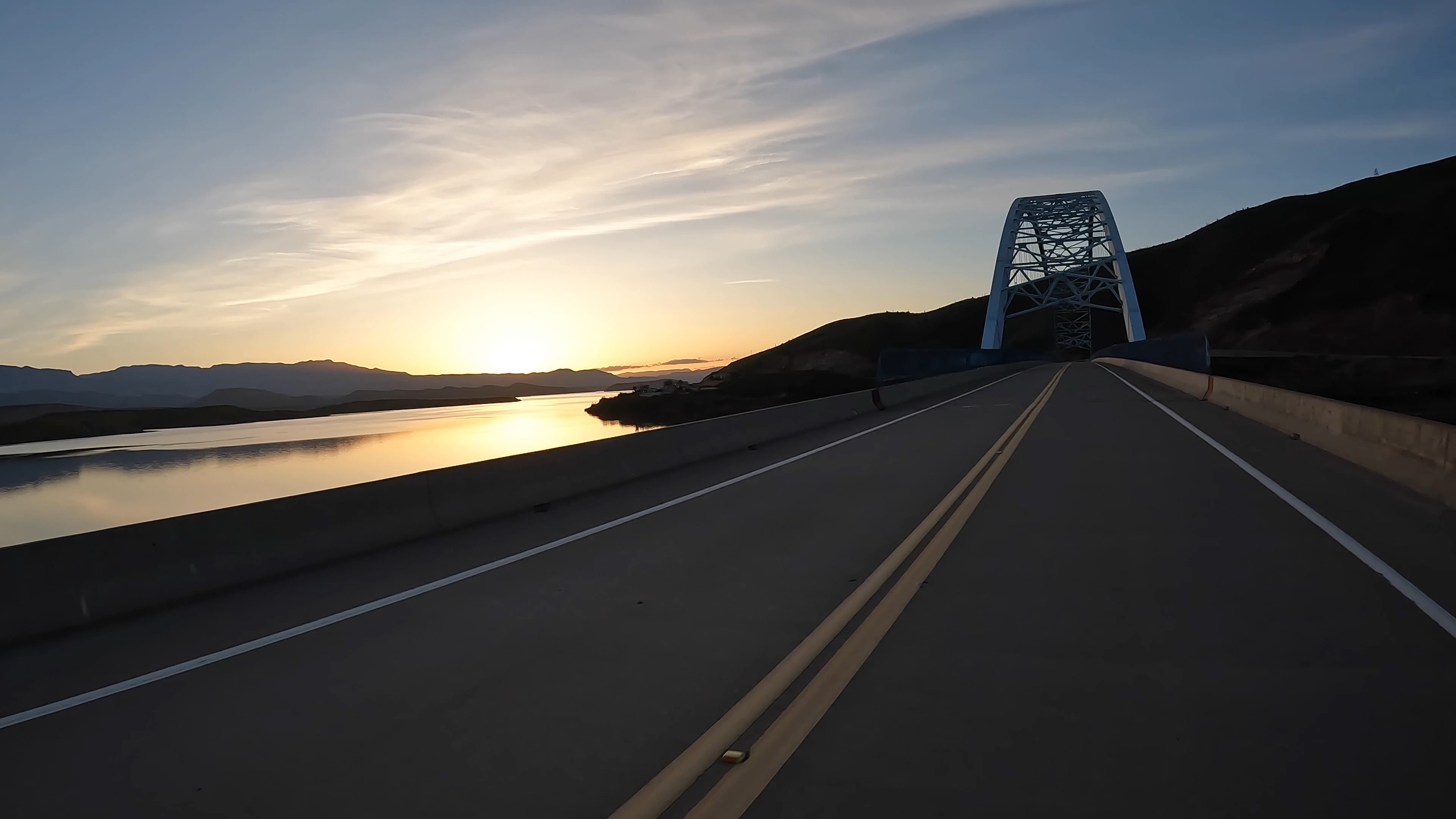
Crossing the Roosevelt Bridge at sunrise

Saguaro cactus on the hillsides at sunrise
Once I left the lake, I began a southward march towards the city of Tucson. What struck me about this stretch of ~150 miles, was the stunning geology. There were miles and miles of incredibly bedded sedimentary layers, as well as countless mountains popping up around the horizon. As I neared Tucson, the view became overtaken by the looming Mt. Lemmon. Once in the city limits, I did have to contend with some morning traffic, which slowed me down considerably, but did mix things up a bit. It felt weird to be moving through traffic lights and dealing with rush hour traffic, but it was only for about 10 miles.

The route to Tucson

Some stunning AZ Sedimentary Geology
Leaving Tucson presented my least favorite section. In order to get across my loop to the Eastern side, the only practical way was to take I-10 for about 100 miles. As I noted, my Himalayan doesn't like to go much over 70 mph, so I opted to sit in the slow lane, and effectively "hide" behind a slow semi or camper van. This way, people just went around me. It was definitely a bit stressful, but I did also take a 10 minute break about half-way through in the town of Benson. Benson was significant in that it also marked the southernmost point on my entire loop. Benson also marked the approximate 1/3 point of my ride (about 330 miles)

Tucking in behind a camper on I-10

The southernmost point in Benson: Mile
About 40 miles past Benson, I finally exited the interstate, and was back on more appropriate secondary highways. This is when the ride really started to get interesting. Both the scenery and the nature of the roads improved greatly. I was presented with varying ecosystems and geologic formations (buttes, pinnacles, mesas, etc.), and the roads became noticeably more twisty. Exactly what I was looking forward to. Eventually I made it to the towns of Clifton and Morenci right at noon, and took a 15-minute lunch break. I knew that leaving Morenci, I would begin the 100-mile twisty mountain road section known as the Coronado Trail. I was really looking foward to this stretch, but I also knew it was going to be slow. I wanted to make sure I got in a good break and took in some calories and hydration before starting. One thing that did surprise me as I came into the town of Morenci, was the incredibly massive open-pit copper mine. Apparently, this particular mine is one of the largest copper mines in the country. I suppose it makes sense given that Arizona is the "Copper State".

Heading into the more twisty and scenic roads

Approaching the Morenci Copper mine
I left Morenci, and after a few miles of navigating through the mine, I was legitimately starting up the twisting mountain road. The Coronado Trail would present me with about 100 miles of difficult riding, but thankfully, all paved. The route starts in Morenci, and weaves its way through various mountain passes and gullies as it makes it's way to the northern terminus in the small town of Alpine. This route reaches a high elevation over 9000 feet, so I knew I would also be presented with cooler temperatures and likely some snow. This area of Arizona is known as the White Mountains region, and it gets the most snow accumulation of anywhere in the state (particularly around the highest peak of Mt. Baldy). Thankfully, it was the warmest part of the day, and I was excited and alert to tackle this section.
Just as expected, I was rewarded on this section with the best views of the entire ride, as well as some frigid temps, and numerous snow drifts. One significant development that occurred during this section was that I hit the half-way point on the ride right in the middle, and it gave me a fun milestone to to keep me motivated during the slow riding.

The Coronado Trail

Starting up the twisty road

Topping out near 9000 feet with a lot of snow still present.
When I made it past the town of Alpine, I was able to speed up significantly and make quick work up to Interstate 40. It was at this point that things really began to change for me. As I crossed the highway, I couldn't shake the feeling that I could have just turned onto it, and headed home. But instead, I was continuing on north away from home. This put me in a real mental low that I just couldn't shake. I had hit the 2/3 mark on the ride (~670 miles), but was no longer enjoying it. Despite rather lovely scenery, the miles in this stretch I dubbed, "the grind". I knew I would hit some low points, but this was a difficult one to shake. I just wanted to go home and was tired of riding. I needed to find some new inspiration. I tried to convince myself that Canyon de Chelly would be a good goal to aim for, but then remembered that I wouldn't actually see the canyon on my route. I was also getting hit with some fairly hard winds making the riding much more difficult. To say that the miles went by slowly would be an understatement. I had to dig pretty deep to keep focused in this section.
But then, sunset came, and it was stunning. I had made it into Navajo Nation and the lanscape was changing noticeably. There were the more-typical monuments of the region, with various mesas and mittens beginning to pop up. As I watched the sun set to the west, and light up these formations, I was reborn with a new sense of purpose. I also had a rather important epiphany. I realized that once I hit the northernmost point of the route at the intersection of Route 191, I would be turning left and effectively heading home. This simple thought, was incredibly motivating and gave me a tangible goal to set for myself. My rough math had me hitting this intersection right as the dusk light would be fading. The turn on to Highway 191 would also be right around mile 800.

The stretch north of I-40 was a difficult grind....

During the "the grind"

Sunset in Navajo Nation

Reaching the turn for Route 191...and heading home (Mile 792)
The next 100+ miles were through the dark. I passed notable checkpoints along this route, including the towns of Kayenta, Tsegi, and Tuba City. The miles through this stretch were long, and went by somewhat slowly, but the fact that I was riding through the night now, just made it feel different. I didn't mind it as much, and in the back of my mind it still felt like I was heading home. That thought kept me motivated. I also had to stay alert for wildlife so was forced to focus. After a few hours, I finally made the turn onto Highway 89, which is the highway that leads back into Flagstaff. Once on this stretch, I had just about 15 miles until the town of Cameron (Mile 935). I made a final stop there for my last gas fill up, and prepped for my final 65 miles. I put back on all of my cold weather layers and prepared for what were going to be some cold final miles.
I really just wanted to head straight home, but I also knew that I still had the sunset crater loop to do. I double checked the math just to make sure, and I confirmed that I still needed this loop in order to hit 1000. There was a part of me that was admittedly curious as to how the loop would be in the dark. I had done it several times during the day, and it does make for a lovely and scenic ride....but I was nervous about how it would go in the middle of the night. By this point, it was almost 11 pm.
When I hit the entrance for the loop just 20 minutes later, I dove in and began navigating the twisty road past Doney Peak, and down towards Wupatki. About halfway through the loop I had a smile on my face and was quite glad that I was able to end my ride with this fun little capstone loop. It was quite an enjoyable little way to end my grand ride. When I did pop out at the southern end of the loop back on to Highway 89, I was now back over 7000 feet, and was presented with the coldest temperatures of the entire ride. I did a quick check on my phone and was seeing a temp of 19°F. It was damn cold. Thankfully, I had only about 15 miles left to end my ride.

Final fuel-up in Cameron (Mile 935)

The Sunset Crater/Wupatki Detour
I made it back into Flagstaff proper about 15 minutes later and hopped up on I-40 for the 4 miles stretch back home. Incidentally, it was while on this stretch of highway that my odometer actually passed the 1000-mile mark. I was glad I mapped out 1009 miles, as my actual mileage ended up being a bit shorter at 1003.4. I had a little gleeful celebration, let out a loud scream into the wind, and the promptly got off the highway for the final 2 mile ride home. To mark the official end of my ride, I had to stop at a gas station and get one final fuel-up with a stamped receipt. I stopped at the gas station just a 1/2 mile from my house, and once the receipt was printed, I felt as though a huge weight had been lifted. I was done. I had completed my grand (iron butt) ride successfully, and without any incidents. The timing was perfect as I had become aware over the past few miles that I was no longer in a good mental condition, and I had become unsafe to ride.
I took my final photos, stopped my satellite tracker, and then fired up the bike one last time. I putted the 1/2 mile home, pulled the bike into the garage, and then promptly collapsed onto the floor. Eventually, I got up, cleaned myself up, and then was in bed a short time later. While I laid there in bed, I could still feel a phantom buzzing in my fingers.
Some stats:
- My official ride track: https://share.garmin.com/on2feet
- My official end mileage was 1003.4
- My official final time was 20 hours and 12 minutes.
- I used about 20 gallons gas ($90 USD)
- I averaged 50.15 mph
- My longest break was about 15 minutes
- My favorite section was the Coronado Trail (but w/ many close seconds)
- Coldest temp was 19°F
- I wore six layers up top to stay warm
- My upgraded seat (Seat Concepts Brand) was a definitely a huge plus. My backside was never that sore.
- I only got off my intended route one time when I went into the town of Morenci (probably added 1/2 mile)
- Scariest section was definitely the Mormon Mtn ice scare at mile 25.
- I saw three bighorn sheep around mile 700.

Mile 1000!

My finish receipt - 11:18 PM

Grand Ride: Complete
Incidentally, less than 24 hours after the completion of this ride, I drove 5 hours up to Zion National Park and ran a 50K trail race, finishing in 5hrs 42 minutes, and placing 3rd in my age group! What a crazy weekend!

Mile 3 at the Zion 50K

Mile 15 at the Zion 50K