
The Geographic Center of Arizona
All right my friends...it's time for another geographic geek-out; another quirky and seemingly bizarre trek to nowhere. Two weeks ago I set out from my home in Flagstaff Arizona with a single and simple goal: to set foot on the precise Geographic Center of Arizona. This is that story....
Now I have spoken exhaustively about geographic peculiarities on this site, and multiple times specifically about geographic centers. There's an entire chapter of my Treks to Nowhere written collection dedicated to geographic centers and my quest to reach as many of the marked "Centers" of the United States as possible. The story of these geographical pinpoints is long and complicated, but the short of it is that it is nearly impossible to identify the exact center locations of any bounded geographic area. This is because, well, the Earth is just not that simple. Land masses are bulgy, wobbly, and imprecise. Marked boundaries and borders aren't always perfect either and sometimes are either diffuse or dynamic. Rivers change, coastlines change, glaciers melt, and even the seemingly unchanging stone bedrock beneath us is at the constant mercy of the always irksome processes of erosion.
Still, we've gotten really good at minimizing the uncertainties, factoring in all of these difficult-to-quantify processes, and crunching the numbers. One geographer at the University of Buffalo, Peter Rogerson, published a scientific paper in 2015 where he presented a brand new method for calculating geographic centers that has since become the most precise method to date (superseding calculations previously made by the USGS). As such, if one were to seek out such a geographic center, these are ostensibly the best available estimates we have today.
What came of this study, were also the published coordinates for the geographic centers of each of the US states. A quick perusal of these coordinates reveals that many of these marked locations do fall within private property. Most points also fall relatively close to public roads and if private property weren't an issue, could likely be accessed via short hikes on foot. Even the geographic centers of large and relatively empty states like Wyoming or Nevada are not that far from 4x4 dirt roads. I will note that, yes, Alaska's center would be incredibly challenging to reach and is far from any accessible road (not surprisingly). Additionally, given the layout of the Hawaiian islands, its center is actually located in the open pacific ocean.
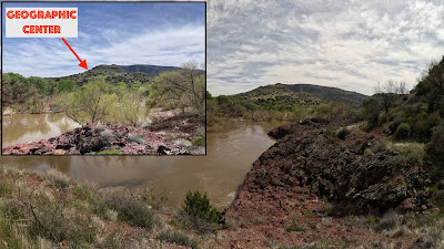
Here in Arizona however, things are a bit different. In simplest terms, our recently calculated and most current geographic center, is NOT easily accessible. Historically, our state's "proxy" center has been marked by the USGS as being located in the town of Camp Verde. There is even an established marker located there. I say that this marker is a "proxy", because even Camp Verde recognizes that the true marker is located miles away within the Mazatzal wilderness area near the confluence of the Verde and East Verde Rivers. On the Camp Verde marker, they note the location for the Geographic Center as 34°16'31.1"N, 111°39'36.8" W.
Geographic Center marker in Camp Verde

The published USGS coordinates for the Geographic Center in Camp Verde

Arizona's Geographic Center

Distance from Camp Verde (~26 miles)
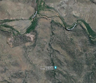
Location near the Verde and East Verde River confluence

The multiple Geographic Centers of AZ
Given the rigor of Rogerson's new calculation method, I have come to recognize his calculations as the most precise for geographic centers. Therefore, when looking into my new home state's center point (AZ), I have opted to acknowledge the most current and updated decimal calculation as the most accurate:
34.2744°N 111.6602°W
SEEKING THE CENTER...
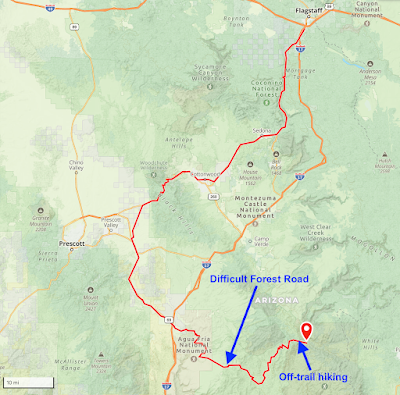
Sometime late last year (2023), an idea began to brew in my head. I wanted to see if I could set out and reach this elusive point in Arizona in a single day. Given the remoteness of this point, and its inaccessibility, I knew this would require some clever route development. I also knew that it would likely require multiple modes of transportation, some difficult off-trail bushwhacking, and at least one river ford. What I didn't realize was just how big of an undertaking this trek would all be, and that it would ultimately take me four attempts to find success.
ATTEMPT #1 (Bloody Basin Rd / Cordes Lakes / Verde River):
I initially plotted out several possible approaches to this point and quickly settled on an approach from the West. This route would involve very difficult and unmaintained forest roads, and therefore the use of my dual-sport motorcycle. The start of this road however, was also located over 60 miles from my home in Flagstaff so would require either a long highway ride first, or for me to load my bike onto a trailer and first drive it down. All of this would take significant time. Once at the approach forest road near the town of Cordes Lakes, I would then have to ride in over 40 miles of rough and rocky trails just to reach the area where I could then start my hike over to the point. This hike would require nearly 2000 feet of descent down to the Verde River, and then fording the river to reach its eastern side. From there, the route would entail a difficult off-trail climb up to the point located in a small drainage on a desert hill side (likely covered with various cactus and cheatgrasses). The roundtrip hike would total around 8 miles (which doesn't sound like a lot, but would be mostly off-trail). This approach, while perhaps "logical" on paper, was ridiculously bold, and I hadn't appreciated just how long it would take to carry out. Still, I went into it rather recklessly and overconfident.
I left my home in Flagstaff entirely too late in the morning for the attempt to ever be successful, but didn't fully realize it at the time. And not only did I leave too late for an honest attempt, but I decided to take the "scenic" route down to Cordes Lakes. I chose to do this as I would be riding my smaller displacement dual-sport bike that didn't do well on the 75+ mph Interstate highway. I also just falsely assumed I'd be able to quickly get through the rough roads and bang out a fast hike over to the center point. The hubris was definitely oozing through on this attempt. The fortunate side-effect of this attempt, while it was ultimately unsuccessful, was that it resulted in a fantastic day of riding my dual-sport bike all over some of the most incredible places in Arizona. My bike was still relatively new at the time, and this attempt allowed me to truly explore some wild and wonderful nooks and crannies of Northern AZ.
My route down to Cordes Lakes took me first down Oak Creek and into Sedona. This is always one of my favorite rides to do on my motorcycles. I made great time down to the Cottonwood area, but rather than hop out onto the Interstate for a short stint, I opted to go up and over the mountains through the ghost town of Cherry. This is a fantastic ride on some killer dirt roads, but takes a fair amount of time to get through. The scenery was spectacular, but I lost at least another hour on this stretch.
Once I made it out the other side on US Route 169, I finally opted to use the Interstate for the final stretch to Cordes Lakes. I finally made it to the Bloody Basin Rd to begin the 40+ mile stretch out to the Verde River at about 11 am (again, way too late for an honest attempt). Just a few miles into the rough roads, I made a wrong turn and ended up on a private ranch (again costing me precious time).
I backtracked to the primary road and pushed on towards the Verde River....but quickly realized just how slow going the ride would be. After about 20 miles of slow and stressful riding, I began to do some quick math. I calculated that I wouldn't even reach the end of the road until almost 3 pm. Adding in an 8-mile hike over difficult terrain would likely add 3-4 more hours. Putting me back to the bike around 7 pm. By the time I were to ride the 40+ miles back to my bike (mostly in the dark) I would reach the highway until 9 or 10 pm. Then I'd be riding home on the highways, and likely not getting back until well after midnight.
I aborted my attempt to reach the center and instead opted to turn my day into a fun day of exploration on my motorcycle instead. I rode back through the mountain town of Jerome and then worked my way back up to the Colorado Plateau through the small ghost town of Perkinsville and eventually up through the town of Williams. I rode my bike up to teh top of Bill Williams peak before finally heading home to Flagstaff. I didn't get back to the house until well after dark, but was thrilled with how the day played out. Despite not reaching the center, I had a fantastic day exploring northern Arizona on my new motorcycle and the entire trip allowed me to get more comfortable on the bike, and really get a good feel for how it performed off road. It truly was a brilliant day.
The planned route...

40+ miles of technical riding...and then difficult hiking...

Heading down to Oak Creek Canyon

The road to Cherry, AZ

Wrong turn onto a private ranch

Heading down Bloody Basin Rd.

The turnaround point

Heading to Perkinsville, AZ

The ride up Bill Williams Peak
ATTEMPT #2 (Deadman Mesa / Strawberry / East Verde River):
For my second attempt, I knew that I needed to get more serious and budget a lot more time. For this attempt, I chose to attack the center from the Northeast by way of the town of Strawberry, AZ. I would plan to ride my Honda again, but this time I would head down the long road out to a feature known as Deadman Mesa. From this approach I could get to within about 7 miles of the of the center, requiring a 15-mile roundtrip hike. This hike would also be on the labeled Deadman Mesa Trail (although there was no way of knowing how maintained it would be). I planned to cover about 2 miles per hour so the hike would potentially take me 8 hours (meaning I'd have to start by 9 am at the latest).

Full route for attempt #2

The route from Strawberry, AZ

Zoomed-in hiking portion of the route
The morning of my attempt I left my house early before sunrise. I planned to get to the trailhead before 9:00 am in order to give myself plenty of time for the hike. The ride down the paved Lake Mary Rd to Strawberry was quick and I was starting up the backgrounds out to Deadman Mesa around 8:00 am. Very soon into the off-road riding the quality of the road degraded to that of a barely discernible trail. It also quickly ramped up in difficulty to the very extreme end of my comfort level for riding. I was dodging large rocks and navigating steep descents. The riding was slow and treacherous and I was losing a lot of time. On a steep section out on the Mesa, my bike rolled on a loose rock and I dropped it hard onto some jagged rocks. Thankfully, I didn't incur any major damage, but it was enough for me to admit that I was now on roads beyond my capabilities. I found a place to stash my bike behind some trees, and chose to hike the rest of the way. This plan would add at least 3 miles to my hike, but I figured I could move quicker on foot.
I began hiking down the road as it continued to get rougher. I was happy I chose to park the bike but it was already past 9:00 am and I knew I was going to be tight on time. It took me almost 5 miles of hiking before I finally reached the end of the Mesa to begin my descent down to the river, and as I progressed down the descent, the trail effectively disappeared. From this point on I was essentially route finding through open terrain. I was constantly getting snagged on briars and cactus, and the descent down was steep and unstable. I was falling a lot and beginning to get worried about my odds of actually making the center point.
About 2 miles down the descent, I began to do the math and once again realized that making the center was not going to be possible in the daylight. In addition, my water supplies were getting low and there was no place to resupply other than the river itself. I made the command decision to abort and head back to the bike. After several hours of hiking, I finally made it back at dusk, and had to then ride out the 10+ miles of very difficult roads in the fading light. By the time I made it back to pavement, it was well after dark I didn't make it home until late evening. I was frustrated by the day, but learned a valuable lesson with respect to Arizona Trails: many "marked" trails are actually unmaintained and present very difficult conditions. Given this, I knew any attempt on such "trails" had to include additional time for slow navigation.
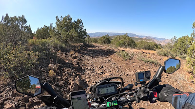
Riding out on Deadman Mesa

Taking a spill...

Recovering...

Off-trail route finding

Starting the descent to the Verde River

Along the steep ridge line descent (and no "trail")
The turnaround point...

Riding back out in the late afternoon

Still on the back roads at sunset
ATTEMPT #3 (Bloody Basin Rd / Cordes Lakes / Verde River):
For attempt #3, I decided to return to the location of my first attempt as I wanted to minimize the amount of time I'd have to traverse on foot. I figured if I could make it in the 40+ miles on Bloody Basin Rd, I could make much quicker work of the ~7 mile round-trip hike to the center from there. Of course the big question mark for this approach is the Verde River crossing. At times the Verde River can have flow rates in the thousands of cubic feet per second...making it impossible to ford safely. I had been watching the public stream gauge data online, and determined that the levels were looking decent for an attempt.
I also decided that for this attempt, rather than lose so much time riding to the approach road, I would instead load my bike onto a trailer, and drive it down to the Bloody Basin road in the wee hours of the morning. This way, I could be starting up the 40 mile road right at sunrise giving me plenty of time for the hike.
I loaded the bike the night before and prepped all of my supplies for a pre-dawn departure. I left the next morning well before sunrise and drove down the 70 miles on the Interstate to the Bloody Basin road exit. I had the bike offloaded quickly and was starting down the road just after sunrise.
The riding out to the far end took hours but was absolutely stunning. Just past the point that I had turned around on my first attempt, the road became much more scenic and thrilling. I descended down a twisty mountain section and then along an expansive and desolate desert stretch. Before long, I was deep into the wilderness without a single soul nearby. As I progressed farther and farther, I couldn't help but feel like I was a million miles from civilization.
When I finally reached the last descent down towards the river I opted to ride the bike as far as I was comfortably able. In the end, I nearly made it to the end of the road, parking just 1/4-mile from its end point.
The hike down to the river was again supposed to be on a "trail", but I quickly discovered that like Deadman Mesa, these trails are mostly overgrown and abandoned. It took me over an hour to traverse the 3 miles down to the river and when I arrived, I was hit with a very sobering realization. The Verde River had swollen over the previous 24 hours and was now a raging torrent. It was well over 5 foot deep moving with flow rates well beyond any safe crossing. I was absolutely crestfallen, but knew there was nothing I could do. The Geographic Center was in view less than 1.5 miles away, yet there was no way I would be able to reach it.
I begrudgingly turned around making the hike back to the bike and then the very long ride back to the car and trailer. I had hours to think about this silly quest of mine on the riding, and had decided that my goal to reach to the center was likely over. I just didn't think I had any more attempts left in me. In the end I decided to give myself a few weeks to mull it over, and maybe see if there was any other way to approach the center that could be doable in a day. I also considered if it was just worth doing as a multi-day overnight with camping.

Loading up the bike

About 25 miles out on Bloody Basin Rd

An abandoned car near the end of the road

A swollen Verde River

How close I was to the center (1.4 Miles)
Location of Center from Verde River

Riding back out

Passing a single 4x4 deep into the ride

Back at the car (around sunset)
ATTEMPT #4 (Twin Buttes / East Verde River):
A few weeks after my 3rd attempt, I did come to discover one additional route that might work as an approach to the geographic center of AZ. The issue with this route was twofold: First, it would require a 24-mile round trip hike, and second, that hike was likely on another unmaintained AZ trail. Of course this meant that my hiking would be slow and inefficient. And while I'ver certainly covered well over 24 miles in a single day on trails before, these would likely be very slow miles. In addition, this route would still require some off-road riding to reach the "trail head". So, despite my earlier conviction to not try this adventure again, I did eventually decided to go after one final attempt...

Route #4
This approach would be similar to my 2nd attempt. I would make way down to the town of Strawberry, AZ, but instead of heading out towards Deadman Mesa, I would instead ride only about 6 miles out to the Twin Buttes trailhead. In my research I did learn that this is an established trailhead and that the trail (Verde River Trail #11) is at least moderately maintained and follow-able.
I left my house in the pre-dawn hours and rode the 75 miles down into Strawberry just after sunrise. I then rode the 6 miles out to the twin buttes trail head on a relatively moderate forest road. The last mile did get a bit more technical, but I got through it without issue, and was at the trailhead not long after.
The hiking over the first 7 miles was easy and was along a once-established jeep road of sorts. The trail was old and overgrown, but easy to discern. Around the eighth mile, the trail changed to a single track and it became much more overgrown. In addition there were numerous cacti and tall grasses that kept snagging my shoes. As I progressed down to the river, I was accruing hundreds of barbed grass seeds in my socks.
I made it down to the river by noon, and from this approach, I only had to ford the smaller East Verde River (which was flowing at a meager 14 cubic feet per second). The crossing was only ankle deep and I was quickly on the other side. The final mile hike up to the center point was brutal and entirely off-trail (despite the marked trail showing it continued in this stretch). I fell into numerous cactus plants (picking up a collection of spines), and had thousands of annoying seeds poking me through my socks.
Despite these setbacks, at approximately 1:30 PM, I finally arrived at the small juniper tree at the precise lat/long coordinates marking the geographic center. I spent about 10 minutes there snapping photos and recording video clips before turning around and heading back to the river.
The 10 mile climb up from the river back to the motorcycle was excruciatingly slow and exhausting. I had recently had a bout with covid and I could tell my lungs weren't entirely back to full functionality yet. The return hike also featured over 3000 feet of elevation gain during the hottest part of the day.
I did eventually make it back to the bike just after sunset (and after 24 total miles of hiking) and was able to ride out to paved roads before dark. The long 70 miles of highway riding back home was all in the dark (and cold)...but I did eventually make it back to my house by about 9:00 pm.
In the end, this quest ultimately took me four attempts, but I did finally find success reaching the geographic center. I can't imagine anyone else has ever sat under that specific juniper to celebrate Arizona's center (especially given that the newly calculated coordinates are only a few years old).
I spent hours reflecting on this long odyssey I had been on to reach this elusive point, and I decided that I was indeed glad that I chose to give the adventure one last attempt.

The final mile before the trailhead


Starting down the trail (mile 2)
Blooming barrel cactus
On the overgrown single track trail
The East Verde River Crossing
Cooling off in the river
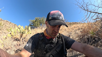
The Geographic Center of AZ!
Grass seeds hitching rides on my socks/shoes
Hiking back up to the bike
Riding out in the dark