
Vermont Long Trail Successfully Completed
InReach Full Hike Log:
So last week I set out to try a different sort of adventure. After years of "putting it off", I finally set aside time to hike Vermont's Long Trail. What made this different though was that I wanted to do this hike completely Unsupported and as fast as possible...just to see what I could do. I knew going into that this would mean it would be a lot less pleasant of a hike, but regardless, I wanted to try. I had never done any sort of "Fastpacking" or "FKT (fastest known time)" attempt, so wanted to give it at least one honest go, if only just to experience it.
For the previous 9 years, the Fastest Known Time on the Long Trail in an Unsupported fashion has been held be my good friend and fellow Barkley alumni, Travis Wildeboer. His time of 6 days 17 hours would be incredibly tough to beat, and I knew it. For clarity, when I say "Unsupported", it simply means hiking the entire trail carry everything needed from the very start, and taking no new food along the way (water from creeks is allowed of course). Hundreds have tried over the years, and none have ever broken Travis's record. When I posted my intention to go for the record on the FKT proboard website (https://fastestknowntime.com/route/long-trail-vt), I specifically noted, "I am neither stupid enough, nor bold enough to declare I'm going after what is a ridiculously stout record by Travis, but I am at least going to try to go hard as I can, and see how things shake out."
Two years ago after coming back from Colorado, and a big Summer of heavy training, I was primed to try this hike. Things just didn't come together though and I had to put it off. So this Summer, when I finally saw an opening in my schedule, I knew I had to take it. I knew I was not as physically trained, and that early Summer would be harder due to increased mud on the trail (and black files), but it was my only possible window. After all of my studying of the trail, and report reading, I was actually feeling moderately confident that I could at the very least keep close to Travis's pace. But then, just a few weeks before I was to start, an accomplished adventurer from the UK named Josh Perry, came over to Vermont and knocked over 7 hours off of Travis's time, bringing the record down to 6 days, 9 hrs, 48 minutes. This was a bit deflating as I knew with my current level of training, that was most certainly out of reach for me. I was super excited for Josh, but it was a hard pill to swallow after getting myself psyched up for weeks. It definitely brought on a wave of regret for not trying the hike in 2017 as originally planned. I shook it off tough and went back quickly into prep mode.
Before going into any details on my hike, and having now made it through the adventure successfully, let me say this as plainly as possible:
The Vermont Long Trail is an absolute monster of a trail. It is extremely difficult, rugged, muddy, and flat-out dangerous in places. I fell several times, once right onto my kneecap (thinking I shattered it). My feet were more macerated than at Barkley, and some of the actual trail was more treacherous than the most technical sections along the Appalachian Trail. Anyone, and I mean anyone, that completes the LT, earns it.
So why did I want to do it exactly? I mean I had already done the AT, and having lived up in Vermont for the past 4 years, I've actually hiked many of the sections around Mt. Mansfield and Camel's Hump already. So why an FKT fast-pack attempt on the LT?
To answer the question of why the Long Trail represents such a special trail for me, and has so many profound memories associated with it, and ultimately why I wanted to do this hike, I have to back to my 2007 thru hike. So...sit back for a bit, and enjoy some story time. Below is from an excerpt a I wrote following my AT thru-hike in 2007, and why reaching the VT border was such a powerful moment for me in my thru-hike.
JULY 16, 2007

On Mt. Greylock on July 16, 2007 - Having decided to just quit my AT thru-hike.
When I couldn’t get a signal on my phone, I sat for a long time trying to answer that question. With less than 600 miles to go, reaching Mt. Katahdin was becoming a very real and tangible goal. For over two and a half months I had been getting up every day before sunrise and walking until sunset, often without genuinely reflecting on why. Hiking the Appalachian Trail had been an idea that I've had in my head ever since I was about six years old and I asked someone what the dotted line on the road atlas was that went through all the states. After hiking with a good friend in the Smoky Mountains in 2006, I had made the decision that the time to attempt a thru-hike was near, but as many can attest to, actually quitting “real life” for 4-6 months to hike the A.T. is easier said than done. Initially, I had credited a rough patch that I had lived through in 2005 and 2006 as my motivation. Following that period in my life, I turned that often vague idea of an A.T. thru-hike, into an actual reality and allowed myself to set an actual start date of May 1st, 2007. There would be a real number on a calendar. I would proudly and philosophically declare to people that I was attempting a thru-hike to “clean my slate” and “start a new chapter”. I would post blogs and journal entries and spout off with various banal profundities like how I was going on a journey to “settle my uneasy soul” and to “seize the day”. It was all so cliché. While I certainly believe that these can be honest motivations with genuine merit, for me, they just sounded like the right things to say. In truth, I wasn’t even sure of the real reasons I was setting out to do this. Perhaps it was just to see if I could. Maybe I just wanted to remove myself from life for a few months.
A lot of my friends and family thought I was being irresponsible for coming to this decision and that this new epiphany of mine was ill conceived. For almost eight years I had what you might call a “normal” life. For all intents and purposes, it was a very stable existence that also happened to pay the bills. To many, it seemed foolish of me to give this up for some kind of “soul search”. At the time I realized that despite not knowing the true reasons for committing to a thru-hike, I knew simply that I had to commit. There was no real way of explaining this to people, it was something that I just had to do. I tried my best to ignore the criticisms and went ahead planning the logistics for my May 1st start date. Everyone has his or her own motivation for setting out on a mental and physical test like this. Over the first 1500+ miles I met people from just about every walk of life, each with their own reasons for being there. Some people were between jobs or “getting back to nature”. Others were simply there to test the extent of their physical capabilities and trying set speed records. What I learned quickly is that no one really questioned anyone else’s reasons. For me, this was a good thing since I didn’t really know what my reasons were. Yet somehow, I had managed to navigate my way through 11 states and over 1575 miles to find myself sitting alone on Mt. Greylock realizing that I wasn’t going to make any further on autopilot. I needed to figure out why I really was there. I thought about my seven-year-old cousin, and it irritated me to know that I was about to let him down. He had been proudly following my progress and eagerly waiting my postcard and blog updates so that he could put pushpins marking my location into the full-sized A.T. map on his wall. Instead of thinking how amazing it was that I made it almost 1600 miles on foot, all he would remember is that I gave up.
For the most part, I had been able to shrug off or ignore difficulties I had encountered on the trail. On days when it rained for 24 straight hours, or when my knees were particularly sore, or when I was getting barraged by swarms of mosquitoes, I was able to focus on the fact that a town stop with a soft bed and shower were coming soon. It always seemed that there was something good coming up along the trail that would be enough to keep me going. When I hit the Massachusetts border though, I had been in a particularly unshakable hiking funk for the previous few days. I was starting to miss my friends and family a lot, and was getting very tired of my sore and aching body. In addition, the weather had been near 100 degrees with extreme humidity all through Connecticut. Things were simply adding up. It was harder and harder to find that “good thing” to keep my mind positively motivated. For the two days leading up to Mt. Greylock, I had run out of bug repellent and was being defeated by the mosquitoes and no-see-ums. During the climb that morning, I felt something change in my mind and I knew that I no longer had enough to keep me going and would become another statistic. Each year, over 2000 people attempt an A.T. thru-hike, with only about 350-400 actually making it all the way. I guess the odds were stacked against me from the start.
So I sat there defeated, trying to muster up the motivation to choreograph my next move. I apologized out loud to my late father for letting him down, and despite the amazing accomplishment of hiking from Georgia to Massachusetts, I felt ashamed that I was now quitting. A part of me tried to focus on the incredible memories that were firmly planted from the previous two and a half months. I thought of the extraordinary people I had met, the indescribable scenery I experienced, and the good stories I’d be able to pass on. None of this seemed to matter. I knew that this endeavor would always be tabulated as a “failure” in my mental book of life. After a few deep sighs and some time to simply unwind, I had accepted my capitulation and decided to enjoy my last day on the trail. I unpacked a whole mess of food from my backpack and treated myself to a little banquet. I no longer really had a need for any of it, so I thought I had at least earned one final feast and the right to go home with a full belly. With a full stomach, and the warm sun on my face, I started to feel a little better. I had accepted my defeat and suddenly the beautiful clear sky and view of the mountain ridges caught my attention. There was a nice breeze and it felt good to just sit. For most of my hike, I had been on an extremely aggressive hiking pace. I started the trail on May 1st, which is about a month later than most thru-hikers start (I had a lot of loose ends to tie up before leaving that held me up). In late August, I was expected to be in Pennsylvania for my first day of grad school orientation. This meant that I had to average about 21 miles a day on the trail to finish it in time. Needless to say, I didn’t have time for many long breaks or days off along the way. Sitting on Greylock, eating more than my “rationed” amount of food, and doing absolutely nothing, felt like a respite that was a long time in coming.
Still unable to get a cell phone signal to make any calls, I pulled out my thru-hikers handbook and started to look ahead at what I’d be missing. I flipped ahead a few pages to the Vermont section to see what kind of climbs I’d be thankfully avoiding and to my surprise, I noticed that the border was only about 10 more miles up the trail. How did I not know that it was that close? Up to this point I had become so accustomed to autopilot, that I didn’t even notice big milestones like this anymore. The closest town, where I could arrange any kind of transportation, was North Adams about 6 miles up the trail. A small thought had started to creep itself into my mind. That thought led to a mentality, and that mentality led me to start rationalizing with myself. I thought, “I have to go into North Adams anyway, so perhaps I should just hike the 4 extra miles and at least get into Vermont. Then, I could hike back into North Adams or ahead to the next town, Bennington, and arrange a ride there. At least I’d be able to say that I hiked one more state right?”I had already managed to pass 10 state borders along my journey, yet for some reason, this one stirred a little excitement in me. My initial thought was that it was because the border also marked the start of Vermont’s famed Long Trail, and I had always wanted to set foot on it. Slowly I began to realize that it was something more. Unlike every other state border crossing, this was the first time where I was driven to one simply because I wanted to be in the next state.
Then, another small thought began to creep into my mind. For the first time in over 75 days of hiking, I was motivated to continue just because I wanted to. It really was that simple. I obviously wanted to hike the trail from the start, but it was at that moment, that the last little flame started in my mind and lit up the thought that I had been trying to manifest since starting my hike. The feeling that I had telling me to put an end to my thru-hike bid, and hang up my hiking shoes, was not because I was truly defeated; it was because I no longer needed to hike onward. For the first nearly 1600 miles of walking, my motivation was one of necessity, not desire. I sat there reflecting on all that I had been through up to that moment, and for the few years prior to the start of my thru-hike. I thought about how the passing of my father, and how I never really was able to face it. In 2005 I went through the motions as I was supposed to, too wrecked to really deal with what was going on. I slowly realized that the catharsis I was now feeling was because I had finally realized the reason I had started hiking in the first place. Whatever little battles I had to fight, were fought, whatever little demons I had to shed, were shed, and whatever goodbyes I had to say, were finally said. That angst I had been feeling all through my hiking, was finally gone.
I sat for a long time at the monument. I stared off into space and gazed at the beautiful mountain ridgelines of southern Vermont up ahead. I was seeing everything with a new set of eyes and honestly wasn’t sure what to do next. It was only a few moments earlier I had tried, unsuccessfully, to call to arrange a ride home, and yet now the idea of continuing into Vermont was one I was becoming increasingly intrigued with.
Everyone has there own reasons for hiking the trail, and everyone comes away from a thru-hike with their own unique memories and stories. Sometimes those memories are of small and seemingly insignificant places along the trail that signify a personal milestone met. Often it’s a specific image of a perfect mountain view from an exposed ridgeline that is ingrained in the mind to carry forever. For me, it wasn’t an in image, no a view, or a mileage milestone. It was at 11 am on July 16th, 2007, that the most important day of my thru-hike was marked. It was on that day, looking across a cloudless sky at a sea of Green Mountains, that thru-hiking the Appalachian Trail went from something that I needed to do, to something that I wanted to do. After about another hour, I gathered myself and continued on hiking into Vermont. When I arrived at the border, I took a picture at the sign marking the start of the Long Trail with a huge grin on my face. I was ready to forge ahead.

At the Long Trail Southern Terminus just as happy as can be during my 2007 thru-hike
A few days later, just north of Killington, VT, I would hit the famous "Maine-Junction" sign that marks the point where the LT and the AT split apart (The LT continuing north up to Canada, and the AT heading North East into New Hampshire, and eventually Maine). I took quick (and very blurry) photos at that point and remember very vividly thinking to myself, "One day, I will be coming down the LT from the North and reach this same sign during an LT thru-hike.

Maine Junction

The Long Trail continuing North from the Maine Junction. This is the section of Trail that I envisioned myself coming down one day during an LT thru-hike.
Knowing just how poignant a moment that reaching the Vermont Long Trails sign was for me during my 2007 hike, the seed was most certainly planted. I knew that I had fulfill that promise to myself to make my way back through the Maine Junction, even if 12 years later. This was a huge part of the motivation for doing this hike. The Long Trail represented that point on the AT where I went from giving up entirely, to starting again, reborn and refreshed. No other place on the AT was as meaningful in the overall picture of my hike.
About a month later, on August 15th, I stood upon Mt. Katahdin in Maine at the northern terminus of the Appalachian Trail having successfully completed all 2174 miles of my thru-hike.
So...back to the present
I didn't take a lot of pictures along my hike, but what few I did are posted at the end of this entry below. I spent most of my time just in my head and concentrating on the terrain. I'm having a hard time remembering specific details about what days were what, but I'm going to do my best below to recap as best I can. I do have my LT map here with me and plan to sort of walk my way through it. I thought it best to start off with some quick thoughts on my hike and the strategies I used....essentially some bullet points before trying to rehash the hike details. So with that said, here are some quick thoughts that come to mind regarding my hike that I thought I'd share for those of you maybe considering a similar hike:
- Here is my full track of my hike. It has a record of my entire hike if you'd like to follow along while reading this report: https://share.garmin.com/johnfegy
- I want to make it clear that while my hike was technically an Unsupported FKT attempt, mentally, that full fire just wasn't there. What I mean is that upon reflection there were definitely times that I know I could have pushed harder, or saved time, or hiked on to one more shelter, but chose not to. More important than trying to break the FKT for me, was simply spending some really important time to myself on the Long Trail before leaving the East Coast next month for the West. I think in that regard, this hike was a complete success.
- The Long Trail is really damn muddy, especially in Spring or early Summer. If you are going hike it then, you will absolutely have wet feet. You can wear Goretex shoes, or do your best to rock-hop around mud, but I guarantee you will still end up with wet feet. It is simply unavoidable. So plan accordingly.
- People often like to talk about how the "Northern Section" of the LT is so much harder than the Southern "AT" section. I always waved this warning off. Having now completed the trail I can say that there is some legitimate truth to this. The Northern section (including, and north, of Camel's Hump), is exponentially more difficult and rugged. The trail is less maintained, and simply more technical. Be prepared for this regardless of which terminus you start at.
- Bugs are quite bad on the LT. For me, because of the wet Spring, the black fly season was still in full effect. Basically the order of insects from North-to-South went: Black Flies until around Camel's Hump, Mosquitos through to Mt. Stratton, and then Deer Flies to the end. It was never as bad as it was on my PCT hike, but I was bathing in DEET almost daily on this hike.
- Like with any multi-day summer adventure, spending this many days pushing hard, means many days of salt-encrusted clothing. This unavoidably leads to osmosis in your skin, resulting in salt blisters. You must stay on top of washing/rinsing clothing or it will lead to bad chafing/blisters. I was pretty good about this, but still got some good blisters in a few places.
- If you are thinking of legitimately going after this Unsupported FKT, plan to get less than 3 hours of sleep a night, do a lot of night hiking, and to hike through the last night completely. I chose to still get some sleep on the final night, costing me about 3 hours. Combined with about 4 hours I lost messing with my water filter (more on that later), and a few other places I lingered too long, I honestly feel as though I should have finished right around 7 days flat...which was actually my originally estimate.
Saturday June 29th
On Friday afternoon, C and I drove up to Jay VT and stayed at the Jay Mountain Inn about 6 miles from Journey's End trail and the Long Trail start. We spent Saturday just hanging out around town and even rented bikes so we could ride the Newport Bike Path up to the Canadian Border. We tried to visit the famous Opera House in Newport VT that straddles the border, but it had already closed for the day. We spent a few minutes taking pictures there and within moments had a border patrol agent pull up to monitor us. It was a little crazy, but we opted to just leave as to avoid any possible confrontation. It seemed a little extreme, but so are the times I suppose. By evening I was all packed and ready for an early morning start. My goal was to get to the start by 5 am, but there was also a forecast for a lot of rain. I didn't want to hike up the Journey's End approach trail in the rain and dark, so told C that I was flexible on start time.


Biking up to Canada on the Newport Bike Path Rail-Trail

Haskell Library and Opera House

US/CA border at the Opera House in Newport

The Border cuts right through the building.
Sunday June 30th (Day 1) - Canadian Border - Spruce Ledge Camp (31.7 m)
The forecast for my start morning wasn't looking good. Rain was forecast for the entire day, accompanied by likely strong thunderstorms as well. I considered pushing back my hike an entire day, but C had to get back to Boston and I really just didn't want to wait another day. I think in retrospect, it might have actually been a smart idea to wait another day since I blame a lot of my later feet issues on the bad conditions I faced during the first day. But, hindsight is always 20/20 as they say. Rather than stress, we opted to just take our time. I had originally wanted to start at 5:00 am from the border, but this also meant leaving the hotel by 4:00 am and starting up the Journey's End trail by 4:30. Instead, we took our time and made it to the parking area by about 5:00 am. Then the two of us, took our time hiking the 1.2 miles up the approach trail to the border monument. It wasn't presently raining, but all of the plants were soaking wet, so I knew I was going to get drenched regardless. We passed the shelter about a mile in, and then continued on to the terminus. Once there, I fired up my inReach, took some official start photos, and then waited until my watch hit 6:00 am exactly. This gave us about 15 minutes to just goof off at the monument and enjoy some time together before parting ways. In addition to the actual border monument placed in the International swath that marks the start of the actual trail, there is also an LT terminus sign about 100 feet up the trail. I walked up to that for some pictures too, before heading back to the monument to mark my official 6:00 am start.
At 5:55 I said my goodbyes to C and thanked her for all of her support in my crazy adventures. I told her I update at least twice a day on the inReach with "check in" messages to note that I'm doing ok, and should I run into any trouble, I'd also contact her. I had a friend offer to pick me up anywhere in central VT should I run into major problems as well. Promptly at 6:00 am sharp, I started the tracking on my inReach, pushed out a "At Trailhead" message, and started my stopwatch on my wristwatch. My hike had begun. I waved goodbye and began my hike. I was fired up and moving fast. I kept telling myself to reel it in a bit. This was day 1.
I weaved my way around curvy and muddy trails in the first few miles, learning quickly that much of the trail was under-maintained and overgrown. This meant a lot of wet plants brushing up against me and therefore getting water into my shoes. Within 1 mile I had wet feet. No big deal I thought...hopefully my valiant taping will hold up just fine. I was very careful to place really good Leukotape on both feet to avoid hot spots, maceration, and/or blistering. I also had liberal amounts of sportslick and trailtoes on my feet to keep them lubed.
I went over a few small "summits" and felt like I was making good progress...although I didn't actually know my distance covered. It felt like several miles though. At one point, I crested a small hill and a wooden sign denoted "Carleton Mtn.". I realized that this was the first "peak" on the trail, a peak I thought I had already passed over 30 minutes prior. I learned right then and there, that miles go by very slowly on the LT...and that I was going to be in for some very long days. There were no views to speak of on the first morning as everything was socked in dense fog. It wasn't raining per se, but I was essentially in a cloud. By mid-morning, I found myself summiting Jay Peak, the first real significant peak of the hike. It had now started raining in earnest and it was damn cold. I made it to the top shivering, despite wearing my full rain gear. I popped in to the warming hut at the building on the top just to get out of the elements for a few minutes and already started realizing how hard this hike was going to be. I was able to get signal on my phone and did a quick forecast check for the week. Thankfully after this first day, the forecast looked fairly rain-free for the week, although with some really high temperatures (90+ F). Coming down Jay peak on exposed rock scrambling, I learned quickly how terrible my Altra Timps were on wet rock. I fell on my ass at least 5 times. I became incredible adept at stepping around suspicious rocks...but still missed one every now and then and ended up sprawled on the forest floor. I still can't believe I didn't break any bones during any of these episodes. Especially with a 25lb pack. I was careful to eat my food despite not being super hungry, so as not to get too behind on calories. By mid-afternoon, the rain had let up a bit, and I found myself at Hazen's Notch Camp shelter (~18 miles). I took my first real break there to eat and rest a bit. Finding good water sources was obviously not a problem and I was filling up when needed using an MSR Trailshot filter. This early in the hike, the filter was still working ok, but I was already starting to wonder how much time I was losing screwing around with it, rather than just using Aquamira.
After a decent break, I pushed on and summited Haystack Mtn. I remember it being a beefy climb, but once on top sort of rolled along for several miles going up and over Tillotson and Belvidere Mtns. On the decent down from Belvidere I noticed that my shoe insoles kept jamming up in my shoes into the front of the toebox. This was incredibly uncomfortable, but I had no way to fix it. Every time I took my shoes off, and adjusted the insoles, within minutes of hiking, they were getting jammed up in the toe box again. Finally I just gave up and took the insoles completely out, hiking with my feet directly in contact with the shoe bottom. This was incredibly destructive to the soles of my feet, not to mention it pulled off all of my tape....but there was nothing else I could do. This single act really doomed my feet later in the hike, and in honesty, I'm not sure what other solution I might have had. I have worn many brands of shoes that perform fine when wet, so I'm not sure why the Altra Timps have such a hard time with wet insoles sliding around. I even tried at one point to super glue them in with my emergency superglue (that I carry for blisters), and it didn't hold. It also meant I wouldn't have the superglue for later when I really needed it.
Around 5 or 6 pm, the sky opened up with a torrential downpour and I was stuck right in it. Of course I was right between shelters, so had no choice but to plod on through it. This only further soaked all of my clothing and made for some really miserable hiking. Around 8:30 pm the rains finally began to let up just as it was starting to get dark enough where I was considering a headlamp. I looked at my position and saw that I wasn't even at Spruce Ledge Camp yet (where Travis made it on day 1). My original plan was to make it one shelter further to Corliss Camp...but I was realizing now just how slow miles go on the Northern LT. I was disappointed, but decided to simply get some sleep at Spruce Ledge, and plan to head out again very early in the wee hours (~2 am). AT 9 PM, just as I was pulling out my headlamp, I got to the lowpoint about 1/2 mile before the shelter. I hadn't noticed the name before on the map, "Devil's Gulch".
In my many years of hiking, I have come to learn any time there is a feature named "Devil's XXXX", it almost always means crazy rock scrambling. I recalled a conversation I had with a co-worker the previous week where she said there was a section way up north on the LT by Canada that was like the Mahousic Notch on the AT. Lots of crazy boulder climbing and scrambling. It now occurred to me as I was beginning to scramble over incredibly wet and dangerous rocks, in the failing light, that this section was Devil's Gulch. I thought to myself, "I am such an idiot...doing Devil's Gulch at dusk, on wet rocks...". Somehow, I made it through without any major incidents, and eventually made it to the blue-blaze trail for the shelter. I hiked over the 0.2 miles to the shelter and quietly cooked my dinner and crashed for the night. There were two other hikers in the shelter that I did my best not to disturb. I slept mostly comfortably, but tossed and turned a lot. I was up a few hours later and back on the trail by 1:40 am. I probably should have tried to sleep a little longer, but was still hoping to make up some time from a wet and rainy day 1.

Border Photo - just minutes before officially starting

Terminus sign just up trail from the border monument.
Monday July 1st (Day 2) - Spruce Ledge Camp - Taft Lodge (Mt. Mansfield) (32.6 m)
I began hiking at around 1:40 am on my second day. This was probably not my wisest decision, but I couldn't really sleep and figured why not make use of the time. It had stopped raining at this point, but much of the trail were thick ferns, that were soaking wet, and that leaned into the trail. So, despite the lack of precipitation, it would be a very wet morning of night hiking. I don't remember much of this second morning other than it feeling very lonely, and very unmaintained. The trail was very overgrown. I eventually made it to Corliss camp about 7 miles up-trail right as it was starting to get a little bit light out. I made a quick video update from the shelter there detailing things thus far.

Leaving Camp at 1:40 am
Update from Corliss Camp
Leaving Corliss, I settled into a rhythm and managed to get through both Butternut and Laraway Mtns in just a few hours. I was at the next shelter (Roundtop) by 10:30 am and pushing on towards the Route 15 and the Lamoille River crossings. At around 11:00 am, I was at the bridge crossing for the Lamoille river just past Prospect Rock. I took a couple pictures here, ate some food and continued on to tackle the ~3000 ft climb up Whiteface Mtn. I could sense that Smuggler's Notch was starting to get close. This was a big milestone spot for me. I knew Travis stayed in the Notch on his second night, and I was hoping to push on to the shelter half-way up Mansfield should time permit.

Footbridge over the Lamoille River

Selfie at the Lamoille
After crossing the Lamoille River, I began the climb up Whiteface on a bikpath first, and then a dirt road. It was honestly a nice change of pace and allowed for me to cover a lot of ground quickly. A large chunk of the 3000 feet of climb up Whiteface was on this dirt road, so I was quite content to just push out 3 mph pace on "easy" (and dry) terrain. By this point, the sun was out in full, and it was nearing 90 degrees F. Quite a difference from 24 hours prior when I was shivering in the warming hut on Jay Peak. I spent most of the afternoon going up and over Whiteface Mtn. and Madonna Peak. The LT on Madonna Peak followed some ski slopes in places, so also allowed for some quick hiking. Working my way over these peaks brought back a lot of memories from my childhood. I spent a summer with my mom and grandma in Stowe, VT with extended family and remember learning all about the peaks in the area. Thinking back to those memories, helped the miles go by faster. It was also turning out to be a beautiful evening, so I was finally really starting to enjoy myself, despite my still-damp feet.
Once on the other side of Madonna, I took a break at the Sterling Pond Shelter. I knew this shelter well, as C and I had day-hike up to it a couple years ago. Smugglers notch truly was in reach now. I spent a few minutes talking with the shelter steward about my hike and then moved on. It was at this shelter that I had remembered I had packed the guacamole and pita breads. I feasted like a king... and it was amazing. Completely renewed, I bolted quickly down to the road at Smuggler's notch. The trail was recently re-rerouted a bit down to Smugglers Notch, but my map and the blazes were current. I followed the the official trail down to the road, but once there, opted to hike the 1/4 mile up to the day-picnic area so I could eat my dinner there and use the public restroom (the same one Travis slept in on his second night). It was only 8:45 PM when I was cooking my dinner, so I made the decision to continue on after eating, up to the Taft Lodge. It would be a tough climb, but I'd rather knock it out at night, then first thing in the morning.
With a full belly, I packed up, and began the slow hike up about 1600 feet of climb in 2 miles to the Taft Lodge. It took me a little over an hour to make it to the lodge and I was in my bivy falling asleep by 10:30 pm.
Tuesday July 2nd (Day 3) - Taft Lodge (Mt. Mansfield) - Montclair Glen Lodge (34.9 m)
I began day three at exactly 3:00 am by making quick work of the remaining climb up to the chin of Mt. Mansfield (summiting at 3:30 am). I was over to the visitors center by 4:00 am, and over the forehead by 4:30 already making my way down to Nebraska Notch. As the sun made its way up, I knew it was going to be a beautiful, albeit hot day. As I started the climb up Mt. Mayo and on to Bolton Mtn, I stopped often to look back at views of Mansfield. It was quite a lovely stretch of the trail.

View of Mansfield from Near Bolton Mtn.

View of Mansfield from Near Bolton Mtn.
Something odd happened as I climbed up to Bolton Mtn. As I made way along the trail, I began to hear a lot of what sounded like automatic weapons fire far off in the distance. At first I thought maybe it was firecrackers being set off for the holiday, but it distinctly sound like gunfire. I figured maybe it was a shooting range, but what was amazing was the obvious automatic weapons fire. I thought maybe it was a police training facility. My tired mind wandered often and I began imagining these scenarios where while I was deep in the woods of Vermont, some kind of riot had broken out near Burlington and there were gun battles going on. It was all a bit surreal....but then something really weird happened. As I was hiking along, listening to the distant sound of gunfire, There was suddenly an incredibly loud, and deeply resonating noise that nearly knocked me off my feet. What was weird was this noise felt like it came from far away, yet still seemed like it was well over 100 decibels. How could this be? What the hell was it it. It sounded kind of like when a really loud bass note hits on a subwoofer. I just couldn't understand how it could be so loud, so far up in the deep mountains of Vermont. What the hell was it? Was this police firing range testing some kind of new sonic weapon? I honestly don't know what else it could be. About twenty minutes later I saw a Northbound hiker and I asked her..."Did you hear that really loud, deep sound a while back?". She said, "Yeah..what the hell was that?" I was glad I wasn't hallucinating, it was generally unsettling. What's worse is that over the course of the next few hours, the sound happened at least 5 more times. I have since spent hours Googling what it could have been, but have not found anything. I really want to know what the hell it was...as it was like nothing I ever heard before. If anyone knows what this might have been, please do let me know. It would have come from the general direction of Burlington on July 2nd.
I eventually began the long descent to Highway 2 (and I89), and the low point of the LT. I noticed on my inReach that my tracking dots were starting to stray from the indicated LT line on the map. I was concerned that I took a wrong turn, but realized that the official LT paper map I was carrying notes that the LT has a new section in this segment. I took the white blaze official trail, but at first glance, it may look as though I went off trail. Rest assured, I did take the official white-blazed Long Trail.

New LT section on the descent to Interstate 89 and Rte. 2
When I hit the road, it was early afternoon, and it was roasting hot. Temps were hovering around 90, and I was exhausted. The direct sun and low elevation were sapping all of my energy. I took a break in the shade and ate another guacamole and cheese sandwich, and chugged almost a full liter of water. It was about this time that I started noticing that I was having troubles with my MSR Trailshot filter. It wasn't pumping correctly and I found myself going through all of the troubleshooting procedures trying to get it to work. This cost a lot of time, and many mosquito bites. Eventually I filled my two bottles and began the road walk on Duxbury Rd. This part of the trail was miserable plain and simple. At one point, the trail veers off into a field that is not maintained at all and just a haven for ticks. I plowed my way through it picking up a few hitchhikers along the way, only to pop back out on the road a mile further down. Very frustrating. After what seemed like an eternity, I finally made the trailhead for the 6 mile climb up to the summit of Camel's Hump. This would be the single longest (and most gain) climb of the entire trail. I put my head down, and committed to a slow pace walk up to the summit. It took hours. If you look at my tracks, I basically started this climb at 3:30 pm, and didn't make the summit until 7:30...four hours later. It was definitely slow going. At the summit, I rested a long while enjoying the breeze that was also keeping the black flies away. I knew deep down that it was still "early" and that I should not stop at the shelter in 2 miles, but rather push on to the next shelter 7 miles ahead. I was definitely exhausted from the climb though and sure enough, when I arrived at the Montclair shelter at 9:00 PM, I cooked my dinner, and decided to get some sleep. Looking back, this decision definitely cost me. I also spent about 30 minutes again screwing around with my water filter trying to get it to work properly. I was beginning to realize that the MSR Trailshot may not have been a good water treatment solution. I squeezed in to a spot in the shelter, put my feet up, and was asleep in minutes.
Wednesday July 3rd (Day 4) - Montclair Glen Lodge - Skyline Lodge (34.5 m)
July 3rd was what I considered to be the last "short-mileage" day. I knew based off of Travis's itinerary, that at the end of Day 4, I should be focusing on pounding out high miles to get to the finish as fast as possible. I would need to step up my daily mileages into the 40's. I started day 4 at 2:40 am, and it was on this morning that I first started noticing my feet were having some trouble. I could feel significant blisters forming and notable maceration. I had been doing my best to swap out dry socks, but the miles and damp feet were simply catching up to me. I recall a lot of ups and downs on the morning of Day 4, and that the sun was particularly hot. Many of the peaks I went up and over were also ski areas, so I was able to look down many open chair lift cuts. It was on Day 4 that I had my first true injury scare. As I was finishing the final 100 feet of climb up to the to top of Mt. Ellen, my right foot slipped on a wobbly rock. The result, was that I came down hard directly onto my left kneecap....into a pointy rock. The pain was intense and I thought for sure I was done for and that my kneecap was split. It started bleeding immediately and I poured cold water over it. I sat there on the side of the trail, within sight of the summit, absolutely pissed at myself for being so careless. I figured there was no way I could continue. Eventually the pain subsided and I stood up. I took a slow step with my left leg, and was actually quite surprised that my leg appeared to work correctly without any major issues other than some pain. I took another step and again, things seemed to work ok. Could it be that my kneecap actually survived intact. I could tell that my entire knee was already swelling up good, but at the very least I figure I could hobble to a road somewhere to bail off the trail. I honestly figured there was no way I'd be able to finish out my hike though...not with over 150 miles still to go.

View from atop Mad River ski area
My pace slowed considerably, and I plodded along, nursing my knee. The trail was somewhat forgiving on the ridge top as it followed ski cuts. When I made it to the next shelter at (Battell), I recall an older gentleman there immediately noticing my knee. He said something like, "Damn, you did a number on your knee. Looks pretty swollen". He wasn't wrong. I had somehow convinced myself that it was ok over the last few miles, but there was no doubt that it was puffy. I spent over an hour at the shelter pouring cold creek water over my knee and I took two Advil of my first aid kit. I still couldn't believe that it wasn't completely shattered. One thing I did notice was the intensity of the black files at this shelter, so I was also bathing in DEET trying to keep them away. It was all definitely a low-point of my hike. I was doing so well, and even survived all of the rain and slick rocks on days 1 and 2, yet wipe out so catastrophically on a dry, sunny day 4 just feet from an open/grassy summit.
I eventually left the shelter in a rather gloomy mood, but figured I'd keep plodding as best I could. I knew Travis had made it to Emily Proctor Shelter, but that he stopped early. I was hoping to at least make it one more shelter (Skyline), 2 miles further down, but at my slower pace, it would be tough. As the evening progressed, I did eventually roll into Emily Proctor just after sunset, and decided to push right on past before even having a debate, so that I could get to Skyline. A mere 50 minutes later (at 10:30 pm), I was rolling into Skyline, and setting up my sleep kit. I cooked a quick meal, and crashed hard. This would mark the last time on my hike that I was effectively "ahead" of Travis's pace. I knew the next day would be my first true test. If I wanted to match travis, I'd have to do 41 miles (he actually did 43)
Thursday July 4th (Day 5) - Skyline Lodge - Churchill Scott Shelter (36.5 m)
Despite the scheduled high mileage, I was actually quite excited about day 5. This would be the day that I would finally make it to Maine Junction and back on the Appalachian Trail. I'd make it to that sign that left such an imprint on me 12 years ago. I knew it would happen somewhat close to the end of the day, so it gave me motivation to move consistently throughout the day. I was on the trail at 3:00 am, a little later than I had hoped for a high mileage day, but I suppose my body needed the sleep. With regards to sleep, it's important to note that I was finding it harder and harder to sleep due to pain in my feet. My routine had become one of propping myself up against my pack (Vol Stat Style), and then elevating my feet up on the wall of the shelters. Generally though, this only lasted about an hour before I started tossing and turning due to a combination of foot pain, and hip pain. So, I was really digging a sleep deprivation hole starting around day 4. This would absolutely come back to hurt my effort in the final days.
In the morning I did my best to make quick work up and down Middlebury gap, Worth Mt. and Gillespie Peak. I recall the moment I finally was able to flip my map over to the other side and it felt like I had hit a huge milestone. It was sometime around here that I mentally started thinking of the shelters as "aid stations". Early on the hike, I definitely skipped past a handful of shelters. But, now, I found myself stopping at everyone as though it were a race aid station. I had a routine. Refill water as quickly as possible (which usually wasn't quick due to the crappy filter I was using), hop into the shelter, pull out my food bag, and then lay back with feet elevated. I would eat some food and then set my alarm for 20 minutes and take 15-20 minute power naps. Taking naps was not part of the plan, and definitely led to my loss of significant time, but I simply wasn't moving well due to lack of sleep at nights and needed to get some sleep. Once I started taking naps, it was effectively the beginning of the end of any honest attempt at the FKT. I hadn't fully admitted that yet, but deep down, I think I knew it.
Leaving the Sunrise Shelter, I had an amazing 6 mile section of super-highway trail. It was awesome, I hiked well over 3 mph, and felt like I was making up so much time. I started thinking to myself, maybe I am still in this hunt. Maybe I can still make this close. Little did I know though, that despite my quick pace, I was still barely hanging on. It was during the section from David Logan Shelter to Rolston Shelter where I hit what was probably one of the lowest points of my hike. This 8-mile section truly felt like an eternity, and I'm not 100% sure why. It wasn't a particularly technical section, but for whatever reason felt like I just wasn't making any mileage. I remember passing Telephone Gap 2.5 miles in and was shocked that I had only gone 2.5 miles. Eventually, after what seemed like endless hiking I finally made it to Rolston Shelter. I checked my watch and it read 6:15. I was a bit annoyed by the late hour and knew it would be a long night if I were to still hike the 11 additional miles up to Cooper Lodge on Killington. I checked Travis's hike report and saw that he mentioned he was pleased he made it to Tucker Johnson Shelter at 6:45 in this section. I was confused as there was no reference anywhere to that shelter, so figured he meant Rolston. I felt slightly better knowing I was still "ahead" of Travis, if only by 30 minutes. I elevated my feet for a few minutes, ate some food and decided to get out ahead before succumbing to the temptation to nap again. Plus I know that the Maine Junction was just 4 miles down-trail. I was eager to finally get back on the AT and say goodbye to the "Northern Long Trail".
Slightly renewed, I started hiking hard miles. The feet were sore, but the knee was doing better. I pushed hard, and right around 8 PM came a crucial point in my hike. As I was nearing the Maine Junction, super excited, I passed an unexpected shelter. What the hell shelter is that I thought?.
Turns out there is an AT shelter right near the Maine Junction that is not shown on any LT maps, because it is technically part of the AT system. This shelter....is the Tucker Johnson Shelter. Damn. It dawned on my immediately that I wasn't in fact 30 minutes ahead of Travis, but over an hour behind him. This was the shelter that he had made it to by 6:45. Shit. I was instantly deflated. How did I lose so much time? Should I have started at 2:00 am? Was it the naps? Was it a slower overall pace? The truth is, it was all of it. I was simply bleeding too much time everywhere. Completely deflated, I hiked on the few minutes to Maine Junction. Instead of a celebratory picture and a snack break, I took a rather depressing photo, and moped on down the trail to highway 4 at Killington. I knew if I were to make it to Cooper Lodge that night, it would be close to midnight. I crossed highway 4, now on the AT, unable to shake the frustration about losing so much time. Dusk was setting in and I could hear fireworks starting to go off over in Killington in celebration of the 4th. I thought how neat it would be to see those fireworks as I was climbing Killington Peak, but was still in such a sour mood, that it was hard to get excited.

Finally reaching Maine Junction

Back on the AT, annoyed at losing time.
I began the climb up to Killington and eventually hit the Churchill Scott Shelter right around 9 pm. Here's the thing, I was actually still in fairly decent shape time wise when I hit the shelter. Had I cooked a quick meal, and set out up the mountain, I definitely would have made Cooper Lodge before midnight...maintaining my planned schedule for the day. But, I just didn't have the fire anymore. I couldn't shake the funk. I ate my meal, and curled up in the shelter feeling completely defeated. I think it was at this exact moment that all hope of breaking Travis's time, or even 7 days for that matter, was really lost. Looking back now, I am annoyed with myself that I didn't push on to Cooper Lodge. I do think I could have made it. It would have been a short night of sleep, but I could have done it. It's these sort of decisions points in an FKT that are so critical. One thing I did note as I was falling asleep looking at my map, was that my trail mileage was 102.5. I was nearly down to double digits. A "simple" 100-miler to go. Ugh.
Friday July 5th (Day 6) - Churchill Scott Shelter - Peru Peak Shelter (38 m)
If I were going to catch back up to Travis on day 6, I would have to bust out a 45 mile day. This seemed so completely out of reach, but at least had to try. Day 6 was a tough one for me. I took no pictures and remember fighting off a lot of mental demons. Thankfully, the weather was still favorable. Although I had noticed on a recent weather check, that the next day (July 6) was scheduled to get intense thunderstorms. I guess I'd cross that bridge when I came to it.
I made quick work up the remainder of Killington, and had a nice visit with some hikers in Cooper Lodge. This annoyed me a bit as I knew was perfectly capable of doing this climb the previous night, but just wimped out. I was starting to notice at this point that my hunger level was really intense, and I simply didn't have the food to satiate it. I began to realize that I might be in trouble with the amount of calories I was carrying. I dug through my pack and found my bag of breakfast Muesli I had made. In this bag, I carried a smaller baggie of Nido powdered milk. What's great about Nido, is that it's powdered whole milk, so is loaded with calories. I also noticed I had two packets of hot cocoa mix. I wondered...what if I mix Nido, with Hot Cocoa mix? Turns out, it makes an insanely good chocolate milk. I pounded that calorie loaded concoction and felt so much better. I still had enough Nido for one more cocoa combo mix, as well as a couple of servings of Muesli...but it would be tight regardless.
I made good time on the 10 miles down Killington to the Clarendon Shelter where I treated myself with a short nap (feet elevated of course). I was starting to recognize places from my 07 thru hike. By afternoon, I was hiking through the Little Rock Pond shelter area, and had fond memories of passing through there on my northbound thru-hike. I talked for a bit with the shelter steward, and pushed on. By late afternoon though, I could feel my energy levels dropping dramatically. I was starting to drag my trekking poles, and no matter what food I ate, it just wasn't enough. My pace was remarkably slow. I knew I either needed rest, or more calories...but only had so much food for the day. I started bargaining with myself and dipped into my dinner chocolate bar early so as to get me "one more shelter". I slowly did make my way to the Lost Pond Shelter by dinner time, and was incredibly deflated to realize that if I were to make it to Travis's stopping point (Bromley Shelter), I'd still have to hike 13 more miles, including both Peru and Bromley Mtns. This seemed incredibly unlikely. I resigned to push to the next shelter at Peru Peak, 8 miles short of the Bromley Shelter and see what time it was, and how exhausted I was. It wasn't until 10 pm that I finally pulled into Peru Peak shelter, and I knew there was now way I'd be moving on. I was set up and asleep in minutes and thought perhaps I'd just leave extra early to try and make up the time. This was a dangerous game I was playing though...analogous to credit card debt. Going further and further into debt, only to try to pay it back by eating more and more into my sleep. It wasn't going to end well and I knew it. But I just had to do it for 2 more days right?
Saturday July 6th (Day 7) - Peru Peak Shelter - Kid Gore Shelter (36 m)
When I woke at 1:00 am, I decided to get going. Somehow in my mind, I thought I was going to push from Peru Peak, all the way to the finish, in one large push...so why not just get started. Essentially this is what Travis did...a ~55 mile last day push over 24 straight hours without sleep. If I were going to do this, it would be 64 miles, or about 100k without stopping. If I were rested, and fresh, totally doable. But it was a pipe dream to think I could do this in my failing, sleep-deprived, calorie-deprived condition. I hiked up and over both Peru Peak and Bromley Mtn. in the wee hours of the morning. I recall going over Bromley having to hold my headlamp at leg level because the fog was so thick. I had to use my inReach many times to verify I was still on trail. I did make it to the Bromley Shelter by 5:00 am feeling pretty good. Had I stopped briefly, and continued on, I might have done ok, but I succumbed to a nap, and was out for over an hour. I desperately needed the sleep, but I knew I couldn't afford it. Not much I could do about it now though. When I woke, I took the last of my pain killers (which I knew was going to really come back to haunt me), and pushed on.
The next 15 miles were actually quite mild with very little elevation gain. While this was a good place to move with purpose, it also meant it was easy to get sleepy. On one stretch, the trail followed a road for a couple miles. Normally I would have loved this, but in my condition I found it incredibly difficult to keep my eyes open. I passed several northbound thru-hikers, and they all looked at me like I was some sort of zombie.

The long, tiring road on day 7

Where am I, I can't quite recall
The morning hiking was a struggle, but I kept at it. I nursed my calories and ticked the miles by as best I could. By mid-afternoon I was finally starting the climb up Mt. Stratton...the last ~4000 ft peak on the trail. The climb actually felt good and by 3:15 pm, I was sitting on the summit checking my phone for signal. I noticed some ominous looking clouds beginning to build and recalled the forecast for "Intense Thunderstorms" that I had seen a few days earlier. I flipped over to my weather app, and pulled up the radar.
oh....damn.
I sat there in the cool breeze and sunshine, staring at a radar map showing an insane line of dark red squall line storms heading straight for me. I was going to get really wet, and have to fight some nasty trail conditions really soon. Plus, I was on top of a mountain, with intense lightning most likely coming. It was around this time that I started hearing a weird air horn being blown. It sounded like one of those plastic ones you'd hear at a tailgating party. I walked over to the steward hut on the summit where an old couple is stationed to keep an eye on things. The woman came out and told me that the horn was being blown meaning everyone had to get off the mountain due to intense weather headed our way. Several tourists who had paid to take a gondola to the summit were told they had to get back on and head down. Apparently shit was about to go South really soon.
Rather than take a nice break, I immediately started my descent. I figured as long as I was mostly down the mountain, the worst that would happen is that I'd get a little wet. I was wrong. Very wrong. Within about a half hour of my leaving the summit, the red storm cells were directly overhead. Inches of rain per hour were falling along with direct lightning right on top of me. It was an absolute deluge. The trail became a raging river and I was sliding and slipping all over the place. After finally getting dry from my first day on the trail, everything was now soaked again....and soaked completely. I had to stop and take my insoles out of my shoes again, and it completely shredded my already borderline feet. I was wearing all of my rain gear....but it didn't matter at all. It wouldn't have mattered if I had my full poncho. I have never in my hiking life, been caught in a storm this intense. This was the kind of squall line you'd see in the Deep South that would bring horrific tornados. It was absolute insanity. At least I was getting a shower I thought. I knew from this point, I was never going to dry out though...and would be wet up until my finish. Whatever little my feet were still hanging on, were destined to be mangled by my finish.
By the time I made it to the Story Spring Shelter, it was 7 PM and I was a wet, miserable mess. The trail had become one long continuous mud puddle. I was a shit show. Still I knew it was too early to stop. I cooked my dinner and didn't really talk to anyone in the shelter. I was not in a very talkative mood. I saw that the Kid Gore Shelter was about 4.5 miles down-trail over relatively easy terrain, so knew I had to at least make it there. Any idea I had of pushing through the entire night were squashed as soon as the rains came. I knew I was going to need to stop one more time for some sleep. I had hoped maybe I could push on to Glastenbury Mtn and the Goodard Shelter, but when I pulled into Kid Gore, a miserable mess at about 10:15 pm, I knew I was done for the day. I poked my head round the opening of the shelter and was utterly deflated to see it was totally filled with hikers. Shit. I just wanted a small sleep area to crash on, and every single space was taken. I surveyed the floor area, and noticed a small patch of floor that I might be able to squeeze into, but would require me laying underneath the wooden platform. This meant not only would I be incredibly squished into a small space on my last night, but that I wouldn't be able to elevate my legs, or really move at all for that matter. In addition, there would be another hiker, literally sleeping less than a foot above me...all very awkward. In some way I had to laugh about it. It all seemed so fitting after that horrific storm I just hiked through. I just kept telling myself....this is my last night. My body was hanging on by a thread and really starting to fail in multiple ways. I distinctly remember having a conversation with myself...and more specifically with my body. I remember saying,
"Listen, body. If you can just get me through one more day of hiking...28.5 miles, I promise you, that by midnight of tomorrow night, you will be sleeping in your own bed." I was sure my body thought was I bluffing though and was going to call me on it.
I should note at this point too, regarding my completion plans. C was unable to pick me up at the finish, but thankfully I had a really good running/hiking friend, Melissa, that was actually participating in a 48-hr trail event very close to North Adams/Williams and the finish of the LT. I had texted her from the shelter and asked her..."do you think you could pick me up at the finish sometime tomorrow afternoon or evening? I would be eternally grateful". Without hesitation, she told me to just text her when I was 5-10 miles from the finish and she'd be there. Otherwise, my plan was to get down into North Adams/Williams and get a motel room somewhere. I honestly hadn't really thought about just how bad things would be if Melissa couldn't pick me up. Looking back now, I would have been absolutely, and completely screwed.
Sunday July 7th (Day 8) - Kid Gore Shelter - MA Border (28.5 m)
I tossed and turned all night on the shelter floor, barely getting any useful sleep. At about 2:00 am, I lay there pondering what to do. It was the first time I had no desire to do anything. I was incredibly uncomfortable, but had zero desire to get up and get moving, despite knowing I was only 28 miles from the finish. I was so completely and utterly apathetic. I simply wanted nothing.
I don't know what it was, but at one point, I finally yelled at myself to get up and was suddenly sitting on the shelter floor. I remember for the first time in 7 days, I was also legitimately very cold. The storm front had finally brought cooler temperatures and with all the wet clothes, I was actually shivering. I needed food and to get moving. I was packed and on the trail within 15 minutes. I took a beautiful sunrise photo from the top of Glastenbury peak

Sunrise from Glastonbury Peak
I hit the summit of Glastenbury right as the sun was rising and I stopped for while to enjoy the summit. There's another fire tower up there and I was able to send a text to Melissa telling her I had 24 miles to the finish and it was 5 am.....so my finish would like be around 4 - 5 PM assuming I could keep moving well. My feet were absolutely trashed and I was realizing after eating "breakfast", that I had about 400 calories to get me through the entire day. I was effectively out of food. It was going to be a rough day. Thankfully, there wouldn't be much elevation gain on the last day.
I hit Rte. 9 and the road to Bennington (the last real bail-out point) by 10:30 am and it was starting to get hot again. When I crossed to the other side and began the very steep, scrambly climb back up to the Harmon Hill, I finally ran out of whatever energy reserves I had. I was sipping my last 150 calories in the form of a powdered drink mix. When I rounded out at the top of the climb after over an hour, I literally collapsed onto the side of the trail and took a nap in the dirt against a tree. It was the first time I had done this on the trail. I couldn't stay awake. I managed to scrape out the last little bit of powdered milk I had for a few dozens calories, but otherwise had zero food left. When I woke about 40 minutes later, I was overcome by a horrific pain in my gut. I thought, crap....did I get Giardia? About two days prior, after constant headaches with my water filter, I switched to using purification tablets. I was supposed to wait something like an hour before drinking the treated water, but I know there were several times I only waited like 15 minutes. I figured I probably picked up a parasite or bug of some kind. Whatever it was, it was awful. My gut was making noises I hadn't heard before. I was about 11 miles from the finish, in absolutely horrific shape. It was going to be a rough final push.
I looked at the map and saw that I had two small "summits" left: Consultation Peak at 2810 feet, and an Unnamed peak at 3025 feet (which I actually came to learn was informally named Billy Lagalo Mtn). In either case though, I wouldn't have to climb more than about 600 feet of ascent to gain either summit. I hit the penultimate shelter, Congdon, and was still doubled over in gut pain. I texted Melissa to update her on my position and asked her if she was planning on meeting me down at the road in North Adams/Williams, or was planning on coming up the actual terminus sign 4 miles in. She said she would hike in to meet me at the finish, and would bring food. Hearing this news, literally brought me to tears. I would never be able to repay her for her kindness.
I pushed on past the shelter, still with no food, and topped out over Consultation Peak. My entire body was aching now, but somehow related to my gut troubles. I stopped at a beautiful mountain pound just after Consultation Peak, about 6 miles from the end, and took a picture. It was one of the only really good shots I took on the hike.
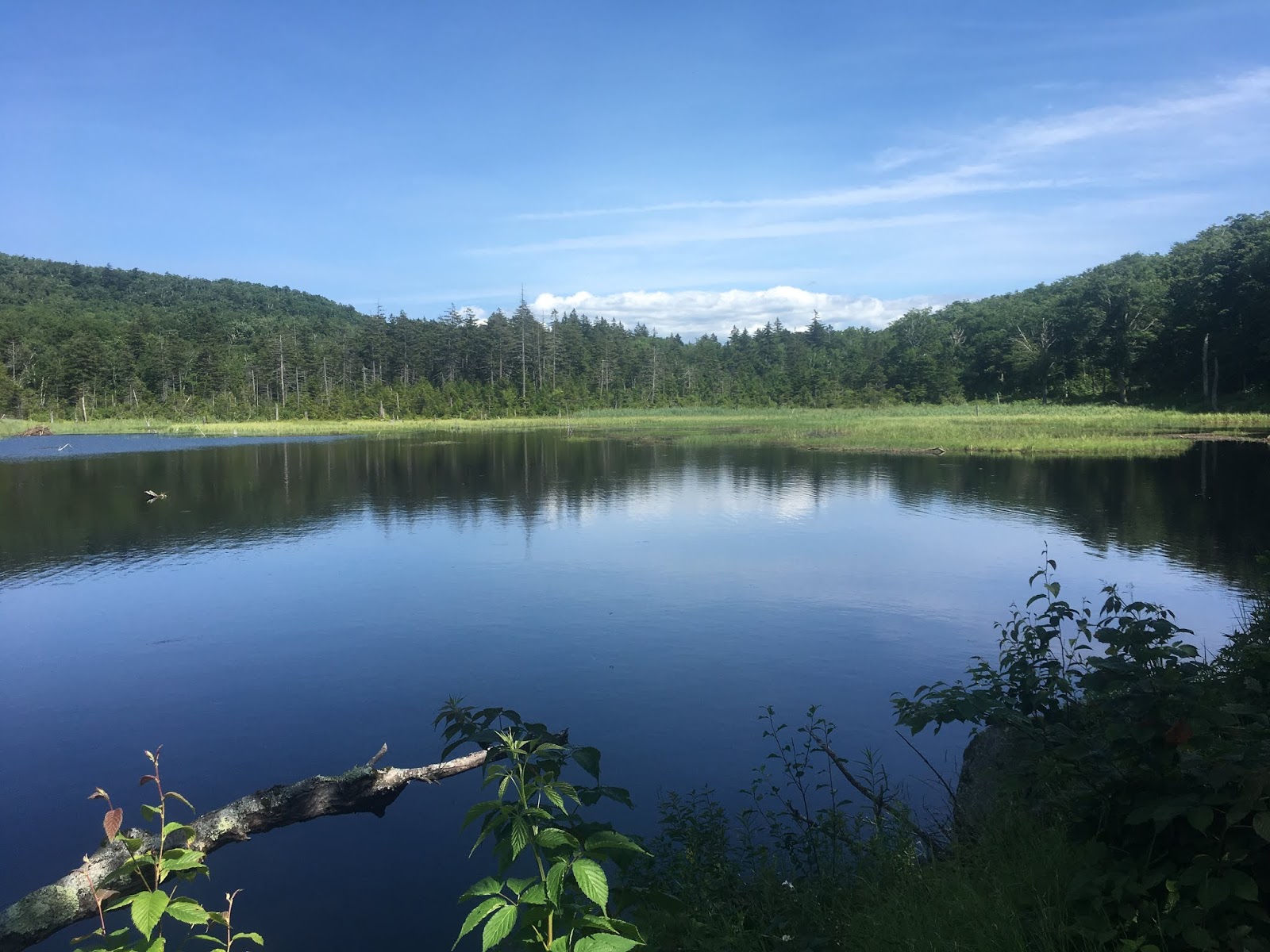
Pond just down-trail from Consultation Peak
As my gut continued to make horrific sounds, it finally occurred to me. I didn't have Giardia...I was literally starving. This is what it real starvation actually feels like. Holy shit it is awful. I thought to all those times I said to myself, "Oh man, I'm starving!", and I felt ashamed. I thought of all the people in the world that are actually starving, and realized how spoiled and privileged I actually am. I was only experiencing the very first stages, and it was agonizing. I couldn't imagine all of those poor people around the world that experience this feeling every day...and worse. I used my phone's camera to look at myself, and could see that my face looked sunk in, my eyes sunk in, and my expression somewhat lost. I looked like I had lost 10 lbs (which is actually what I did lose). I just had to make it 6 more miles I thought.
Two miles further down the trail, I finally topped out at 3025 feet on what was marked as Billy Lagalo Mountain...the last high point on the trail. I took a picture at the summit to remember the feeling of finishing the last big climb. It was about 4:45 pm. I texted Melissa and told her my ETA for the border would be close to 6:00 PM. I was hoping to finish before 6 so I could have a final time of under 7.5 days.

The last "summit" - 4.5 miles to go.
As I descended from Billy Lagalo Peak, I eventually came upon the last Shelter - Seth Warner. I recalled staying there on my AT hike having just made it into Vermont. This time, I didn't even stop. A sign shortly after the shelter blue-blaze trail indicated 2.8 miles to the MA border. I was less than an hour away. Over the next ~3 miles, I tried to forget about the hunger and thought back to all of the memories from the hike. I laughed about the ridiculous rains on day one, and the insane storm over Mt. Stratton the previous day. I thought back to the weird deep-resonating noises I heard near Mansfield, and great people I met at all the shelters. I laughed at myself for not packing enough food...declaring myself an idiot multiple times. I chided myself for all of the lost time at creeks, and at shelters napping, but it was all in the past now. I thought back to my AT thru-hike and how I almost quit on Mt. Greylock....and then how I felt upon reaching the Long Trail sign at the VT border. I just had to walk for 2 more miles, and I'd be done. With about 1 mile to go, I stopped and took a single photograph from the trail. This photo is just of a random section of wooded trail...but I wanted to remember how I felt with 1 mile to go...just how desperately I was ready to be done.

Random trail photo 1 mile from the MA border and the finish.
I checked my inReach and it showed I was less than 1 mile to the end. There of course was a slight climb up to the finish, but I didn't care. All I wanted was to see that sign, see my friend, and eat something...anything.
At 5:42 PM, 7 days, 11 hours, 42 minutes, and 48 seconds after starting from the Canadian Border, I rounded a final corner in the trail and saw Melissa standing on a rock. To her left was the sign I had waited 7 and a half long days to see. I tried my best to hold it in, but couldn't. The tears welled up and as I reached the sign, I collapsed on the ground while cradling the post of the sign. It was over (well mostly). I pulled out the inReach and punched the pre-set message, "At Trailhead" and sent it. It was official now.
I eventually gathered myself, stood up, and gave Melissa an enormous hug. I gobbled up some snacks that she brought as she told me how hard it was for her not the cheer for me those last few yards. She had wanted to hike up trail to meet me, and cheer for my finish, but said didn't want to risk any semblance of "support"...so waited until the moment I touched the sign to actually say anything. I laughed, but did appreciate it. It's so ridiculous the thing we do to ourselves. I put my pack back on, and took a few photos at the sign for posterity, and then the awful realization hit me...
There were still 4 miles to hike, downhill, and my feet were 100% completely trashed. I was going to be an absolute mess getting to the car. While I did have some calories finally in me, I hadn't realized just how bad my feet had become. Over the past 5-10 miles, I had sort of blocked out the pain knowing I was in the "home stretch". But now, having "finished", my foot pain came in with full intensity. I honestly didn't know if I was going to be able to make those 4 miles....considering that it was also a 2000 foot descent, part of which included a technical boulder scramble.

A very happy, albeit 10 pound lighter version of me, at the finish.

Terminus Sign close-up
I can say this next sentence without any question or hesitation. The final 4 mile descent down to the road in North Adams/Williams, were the most difficult and painful of my entire hike. I felt awful that Melissa had to hike so slowly to stay with me. I was a complete mess and in excruciating pain. I kept telling her to just go on ahead to the car and that I'd make it eventually. She never did though, and stayed with me as I hobbled and winced my way down the mountain. At some point on this descent I realized just how screwed I would have been had I been alone at the finish. I truthfully could almost not even walk. I was leaning on my poles and every step was a challenge. The boulder scramble section was....interesting
After well over two hours to make the 4 miles down the mountain, we finally popped out near the road. I stopped at a house near the trail entrance that offers a wash hose to hikers. I sprayed off my legs and shoes of all the mud and splashed my face in a vain attempt to wash out some of my terrible hiker stench. It didn't work. I had a good funk going on.
We made the sidewalk and walked along the road for about a 1/2 mile until we finally came up on the parking area. Melissa popped open her car, and after 7.5 days, I finally felt like I was actually done. I sent one final message from my inReach "Safely at Car", and turned it off for the last time.
I cleaned up briefly using some wet-wipes, took off my shoes, and collapsed into the front seat of the car. We stopped at a pizza place in town for a couple of quick slices, and then began the 2 hour drive back to Boston. I slept nearly the entire way. It's important to note here that Melissa had just run a 48 hour trail event and then drove through the evening straight to get us home.
I finally arrived at my apartment in Boston at about 11:30 PM, said my goodbyes, and immediately jumped in the shower. My feet were ridiculously swollen. I was falling asleep standing up. I eventually hobbled my way into the bedroom, pounded 3 Advil and a glass of water, and laid down in my own bed.
It was 11:55 PM. I smiled and told my body..."See I told you...you'd be in your own bed by midnight. You thought I was bluffing didn't you?". With my feet elevated on 4 pillows, and a smirk on my face, I fell asleep and slept for 14 straight hours.

Hobbling my way down the final 4 miles with Melissa.
Don't let my smile fool you, I was in a colossal amount of pain.
SOME GEAR DETAILS AND NOTES
- For a pack, I used my 2006 golite Jam, and it worked perfectly. I carried 7 days of food comfortably and two 1-liter water bottles that I refilled regularly. Depending on what type of sleeping strategy you go with on a hike like this, I can easily see using a FastPack-style pack. I think if I had access to an Ultimate Direction Fastpack 35 or 45, I might have used that instead simply for the shoulder pockets. As is, I had to rig a shoulder pouch to hold my inReach tracker.

2006 golite Jam
- For sleep strategy, I went with a somewhat risky approach, but after talking with Travis, felt that I would be fine. I carried no tent or shelter, and relied solely on trail shelters for places to catch sleep. I also carried no sleeping bag, and slept in an emergency bivy by S.O.L. It weighed nothing and was incredibly warm (despite being a bit loud/crinkly). For sleep pad, I carried an old Bozeman Mountain Works Torso-length air pad. It is just big enough to fit under your torso and can be wrapped around the inside of your pack to form a "frame". I don't think it's available for sale anymore. I had considered bringing no pad, but knew I needed something to allow me to sleep with at least some tiny level of comfort. For a pillow, I just used a small stuff sack that had my long-sleeve shirt, and extra socks in it.

Bozeman Mtn. Works Torso-pad

S.O.L Emergency Bivy
- For water treatment I went with the MSR TrailShot pocket filter. I bought this last year thinking it would be the perfect solution not only for my LT hike, but for long training runs in the mountains. Let me be perfectly clear when I say this next sentence: This product is ABSOLUTE GARBAGE. Every single person I saw with one of these complained about it. It generally worked ok for about 2 days, but then started having flow issues, wouldn't pump fully, or simply wouldn't work at all. I spent so much wasted time troubleshooting this horrible piece of crap alongside creeks when I should have been sleeping or hiking. I estimate I lost over 4 hours just fiddling with this thing. I was taking it apart, shaking out the filter, cleaning o-rings...it was so absolutely frustrating. I cannot stress this enough. This product is terrible. I brought aquamira with me as a backup, and after struggling with the trailshot for days I finally just switched to treating my water. I was in and out of creeks in seconds refilling my bottles with the Aquamira. I normally hate leaving negative reviews about products, but I truly wouldn't feel right about not saying anything here. I highly recommend, if going for an FKT, just using purification tablets or Aquamira drops. Don't mess around with filters....as it just takes too long. The one exception that I did see a lot of thru-hikers using, were the Sawyer screw on filters that fit right onto normal bottles. Those do seem quite convenient.

Major thumbs down for the MSR Trailshot. Definitely not recommended.
Absolute piece of crap.

Instead, go with something like Aquamira.
So much easier, and they even sell it in simple tablet form now.
(and only have to wait ~15 minutes for it to work)
- I packed 7 days of food, and it took me 7.5 days to finish my hike. Yeah...the math didn't work out...and I hiked over 24 hours literally starving myself. It was agonizing. I cannot stress this enough...bring more hearty and fulfilling foods on an FKT hike like this. Ultra food, or high-energy bars will not cut it. I thought I had a good mix of hearty foods, but in the end was struggling to eat what food I had. At the very last minute before starting at the Northern border, I added some cheese wedges and some guacamole spread. I was so grateful I did. Still, I hiked the last 50 miles on something like 400 calories....and lost about 10 pounds. However long you think it might take you, bring at least 1 full day extra food. I only brought 1/2 day extra food and definitely regretted it.
- Many that attempt hikes like this eschew a stove for the cooking of any hot meals. I was on the fence about this, but after reading Travis's report again, I realized it was worth the weight to have heartier (and hot) meals at night. I carried my Caldera alcohol stove kit that employs a small can-style stove in combination with a Fosters beer can to boil water. It is extremely light weight and also allows for carrying two small plastic cups for eating out of in needed. I mixed my muesli in those cups in the mornings. I carried about ~6 oz of HEET fuel.
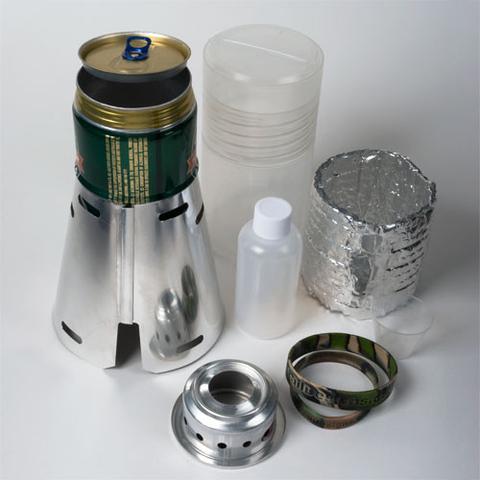
Caldera Stove

Caldera Stove sealed up
- No matter how hard you might plan or try to avoid it, going for an FKT on the Long Trail will absolutely, no doubt, destroy your feet. It is unavoidable. I don't care how well you tape your feet with Leukotape, or use TrailToes or Sportslick lube...it doesn't matter. Your feet will be mangled and destroyed. If you read anyone's FKT report for the LT, they all talk about they're trashed feet. For me, I was greeted with an entire day of rain on day 1, which completely ruined all of my valiant feet-taping efforts. After that, my feet were doomed. I was frankly surprised they did ok until about day 5 when my hike started to fall apart in earnest.
- For shoes I went with the Altra Timps 1.5. These are pretty good trail shoes, especially if you like (or need) a wider toe box like me, but I have two major complaints about them. First, they are absolutely terrible on wet rocks. I slipped (or completely fell) so many times, that I'm frankly surprised I didn't break any bones. Altra needs to put a stickier outsole on this shoe. My second major complaint is with the insole. This is the only trail runner I've worn where when they get wet, even slightly, the insole immediately starts to fold and creep up into the toe box as soon as you start going down any moderate descents. I tried to superglue the insole into the shoe, but it didn't help. Ultimately, I had to use them without the insole at all for the entire first day, which only chewed up my feet even worse. For socks, I swapped through a combination of Darn Toughs, and Injinji Toe Socks (3 pairs total).

Altra Timp
- For rain gear I went with Ultimate Direction's Deluge coat and pants. I originally planned to use my golite poncho-tarp (and it would double as an emergency shelter too), but at the last minute switched to the UD combo. I went with the Deluge instead of the "Ultra" because despite being non-breathable, it was effectively more water proof. The coat also acted as a secondary layer for cold mornings, which is also why I went with it over the poncho tarp. The combo worked fairly, but just like anything that's not a poncho, it ultimately did leak some.
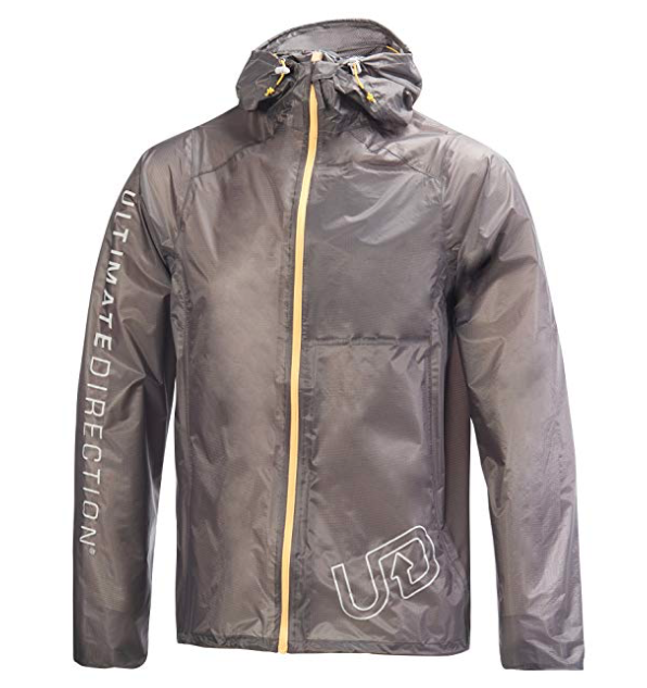
Deluge Coat

Deluge Pants
- For a digital tracker, I used the inReach Explorer. I had originally wanted to get the Mini, but since I already owned the Explorer, couldn't justify the cost of buying a new one just to shave a few grams. I had thought I would use a SPOT, but my experience with the SPOT has been less than stellar. InReach also uses the Iridium satellite network, which I know and trust. The larger Explorer does weigh a bit more, but also allowed me to have the full VT map loaded on it to act as a backup GPS. This map even included the full LT track for reference which was incredibly helpful. There were a few times when I thought I might have gone off trail, but the inReach was able to confirm I was on track. Also, it operates in what's called a "Extended Tracking Mode", which essentially sends a tracking point every 30 minutes, and shuts itself down in between. This allows it to run on a single charge for up to a week. I did bring a small Anker power charger and juiced up the Explorer once just to be safe, but I sincerely think it would have lasted the entire time on one charge (although just barely). I carried it in a small pouch I rigged to my shoulder strap and it worked perfectly there as it had clear view of the sky. The inReach does require a service plan, but you can purchase a single month of use, which is what I did. It allows for unlimited preset messages to be uploaded. As far as how it worked...well apparently it worked nearly flawlessly and uploaded my tracking points right on schedule. When I sent out messages, those were also posted successfully. I was able to give a link to a shared map to my friends and family (as well as the FKT proboards), and people could follow along.


A zoom out showing my full track.

A more-zoomed-in look at my 30-minute tracking points
(red-dotted line is the LT on the basemap)
9 comments:
Incredibly interesting. I too want to rehike the LT, this time southbound, in Sept and follow the foliage show. I won’t be shooting for any records. Survival will do. Keep on trucking, Lakewood
Uncle Tom
LT NB 2011
Nice write-up; incredible effort. Looking forward to hearing about it over a beer. Did you ever figure out what the noise was?
Don
Awesome report! Really enjoyed the whole thing. You had some real hellish weather, but great job finishing in a very respectable time.
Update on noise: The gunfire was definitely from the Ethan Allen Military firing range at the base of Mansfield. I'm guessing the very loud noise was also associated with something being tested there.
The Katadyn BeFree is another good water filtration option. It takes me about 30 seconds to fill it and transfer 500 ml of water into a secondary container. Less than two minutes to replenish a 2 liter bladder.
John, I experienced what I assume was the same sound in the area this past Saturday while on a shakedown hike, so it likely wasn't an isolated incident. I was going nobo and pretty sleep deprived descending Bolton when I heard it (would have been sometime in the afternoon). I remember wondering if I was in a similar area to where you heard it, and after reading your write up again, I'm pretty sure I was.
Your write up helped get me motivated for the my shakedown hike. I was definitely pulling from many of the things I remembered from you report while I was out there.
I'll also second Ryan's BeFree recommendation, especially for shorter stuff where the drop in flow rate doesn't become an issue. I find you can at least go a week or two before you see a drop in efficiency.
Hey I've lived in the Burlington area for a couple of years and have spent a ton of time in the Mansfield area. That deep resonating noise you heard was the testing of a Vulcan machine gun, firing so fast it sounds like a continues sound. I've heard a multitude of times myself there. Hopefully that answers your question.
Anonymous.....I think you're right on the sound! I found this video online and if you go to 46 seconds in and listen to the two Vulcan sounds...it is exactly how I remember the noise! Thanks for solving the mystery.
see here:
https://www.youtube.com/watch?v=Zsf38NYzo5Q&feature=youtu.be&t=45
You are amazing. You are a wondrous man. So authentic a write up. So human. You inspire me to never give up, to keep on going. Congratulations on your successful journey. -Trez (trezzz) Villaine, 60yo Boomer in San Diego
Post a Comment